
View data
All data is visualized in an interactive map application, where you can create your own custom views for specific species or locations.
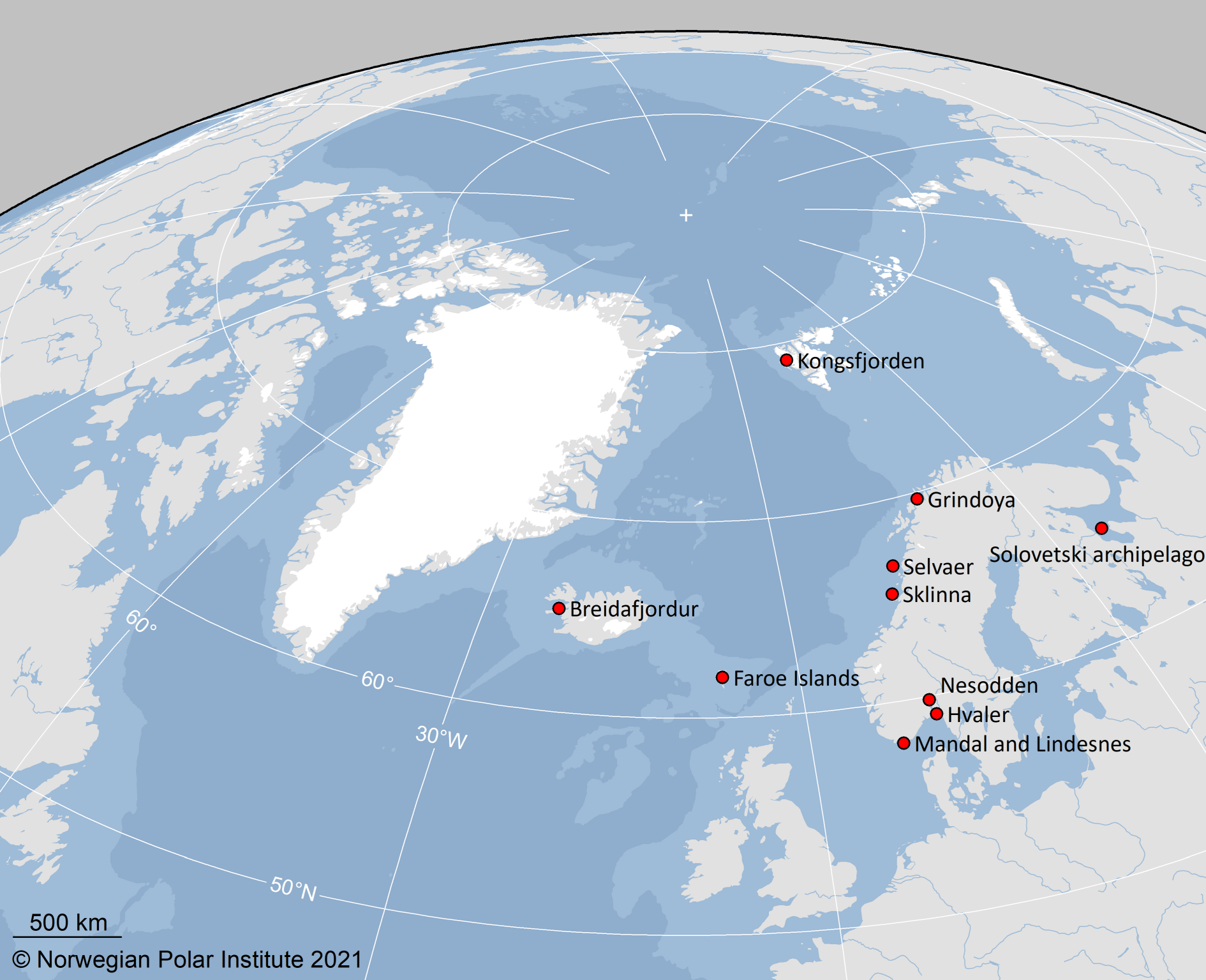
SEATRACK aims to map the non-breeding distribution of seabirds breeding in colonies encircling the Labrador, Greenland, Barents, Norwegian, North and Irish Seas, which includes colonies in Canada, Greenland, Russia, Norway incl. Svalbard and Jan Mayen, Iceland, the Faroe Islands, Ireland and United Kingdom. SEATRACK has been a module to SEAPOP since 2014. Learn more about SEATRACK
Locations
Canada
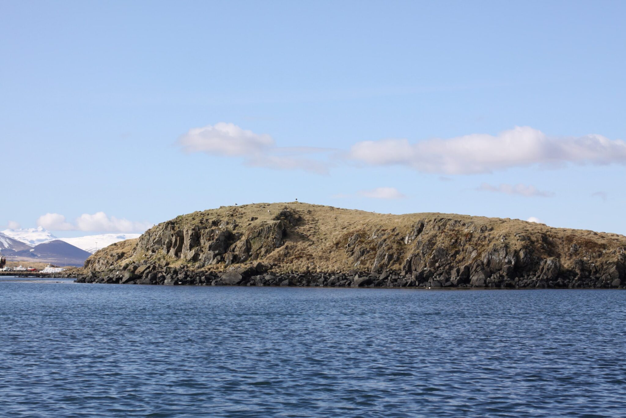
Cape Graham Moore, Canada
72.867°N x 76.067°W
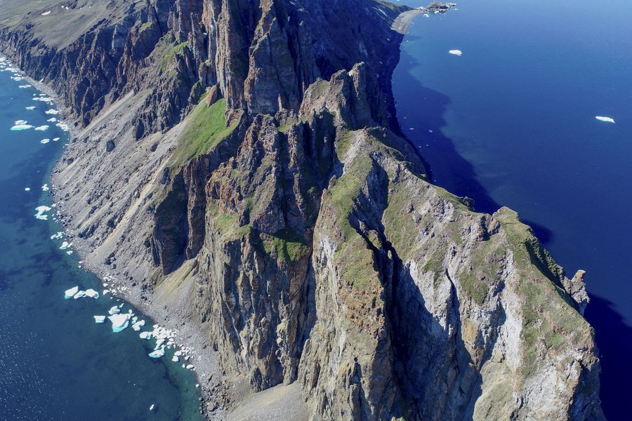
Cape Graham Moore is on the southeastern tip of Bylot Island. Most of Bylot Island is part of Sirmilik National Park. Approximately 100 000 Brünnich’s guillemot nests there alongside about 50,000 black-legged kittiwakes and a small number of glaucous gulls. In recent years, as part of an environmental impact assessment for Baffinland Iron Mines whose ships pass by the colony, researchers have visited Cape Graham Moore in 2014 and 2016.
Site coordinator
Species
- Brünnich’s guillemots [Currently there are no data available]
Coats Island, Canada
62.583°N x 82.749°W
Coats Island the largest uninhabited island in the northern hemisphere south of the Arctic circle, at about 5500 km2. The Inuktitut name Akpatordjuark refers to the murre colony near Cape Pembroke at the northern tip of the island. Approximately 100 000 Brünnich’s guillemot nests there, with 60 glaucous gulls. The colony occurs on Inuit Owned Land administered by the Kivalliq Inuit Association. Two sub-colonies, separated by about 800 m, make up the Coats Island colony and most work occurs at the west sub-colony.
Environment & Climate Change Canada has run a camp annually at Coats Island since 1981, with population size, adult survival, chick banding, feeding observations and reproductive output monitored in most years.
Coats Island became a SEATRACK location in 2019 with GLS loggers being deployed on Brünnich’s guillemots and glaucous gulls.


Site coordinators
Species
- Brünnich’s guillemots
- Glaucous gulls [Currently there are no data available]
Digges Island, Canada
77.750°N x 62.870°W
– Description to be added
Deployment of GLS loggers on Brünnich’s guillemots on Digges Island took place pre-SEATRACK but shared with SEATRACK subsequently.
Site coordinator
Species
Funk Island, Canada
49.757°N x 53.181°W
– Description to be added
A video of Funk Island can be seen here.

Site coordinator
Species
Gannet Island, Canada
56.530°N x 53.940°W
– Description to be added
Deployment of GLS loggers on common guillemots on Gannet Island took place pre-SEATRACK but shared with SEATRACK subsequently.
Site coordinator
Species
Minarets Island, Canada
61.830°N x 66.950°W

The Minarets (66 56’N, 61 46’W), on the eastern shore of Baffin Island, is now called Akpait andis a National Wildlife Area. It is one of Canada’s largest Thick-billed Murre colonies, estimated at 133 000 pairs, or about 10% of the Canadian population in 1985. The site also supports Northern Fulmars (~20 000 breeding sites) and Black-legged Kittiwakes (~1200 nests). Glaucous Gulls and Black Guillemots also breed here. Inuit traditional knowledge, and a collection of one individual during research in the early 2000s, shows that Atlantic Puffins occur at Akpait. This marine region is used by seabirds from mid-April through October, and is also important for many marine mammals.
Deployment of GLS loggers on Brünnich’s guillemots on Minarets took place pre-SEATRACK but shared with SEATRACK subsequently.
Site coordinator
Species
Prince Leopold Island, Canada
74.031°N x 90.067°W

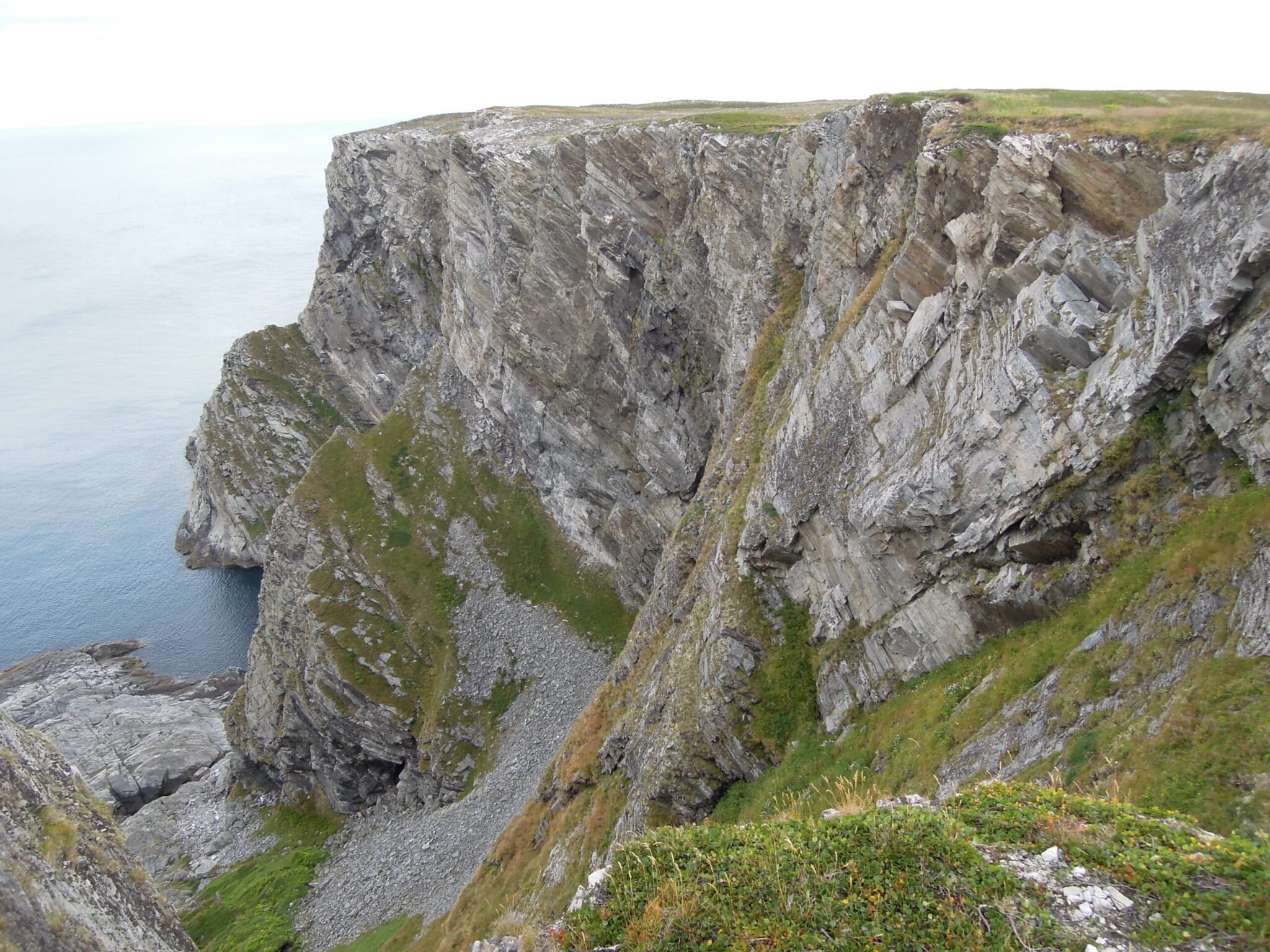
Prince Leopold Island, affectionately known as “PLI” (and often “Alcatraz”), is a stunning Migratory Bird Sanctuary situated on the Northwest Passage, where Lancaster Sound meets Prince Regent Inlet. The island is entirely a Migratory Bird Sanctuary protected and operated by Environment Canada. PLI is approximately 11 km wide with 330+m cliffs on virtually all sides, and sits 13 km northeast of Somerset Island. The Canadian Wildlife Service initiated a seabird monitoring program at this location in the mid-1970s, and much of that work, particularly on Thick-billed Murres (Uria lomvia), was summarized in the seminal monograph “The Thick-billed Murres of Prince Leopold Island”, by Tony Gaston and David Nettleship. Led by Environment Canada’s Tony Gaston (for population research) and Birgit Braune (contaminants research), studies have continued at PLI to the present, and my teams have been fortunate enough to collaborate with these superb scientists. The island supports breeding populations of Thick-billed Murres, Northern Fulmars (Fulmarus glacialis), Black-legged Kittiwakes (Rissa tridactyla), Glaucous Gulls (Larus hyperboreus), and Black Guillemots (Cepphus grylle). It is a breath-taking, multi-species seabird colony.
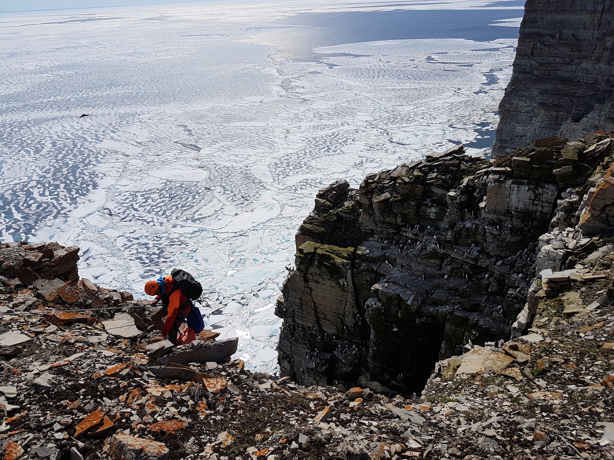
In most years, the floe edge (where open water meets the pack or landfast ice) is situated at PLI in early June, meaning that both marine birds and marine mammals are common around the island. Breeding success of seabirds at the site is highly dependent on ice position and duration.
The field station has 2 cabins (as of 2011), one for sleeping up to 8 people, and a small kitchen cabin. Although Polar Bears (Ursus maritimus) are uncommon on the top of PLI, they are common along the spits at the base of the cliffs. Hence, all people working at the site are required to carry and know how to operate shotguns, as well as having Standard First Aid certification. There is no running water; in fact our water supply is from snow that we melt and store in blue barrels, or from a shallow meltwater pond shared with kittiwakes, so we have to be careful through the season. Showering is clearly optional. Access to the station is by Twin Otter or helicopter. A full field season runs from early June to late August.
Site coordinator
Species
- Black-legged kittiwakes [Currently there are no data available]
- Brünnich’s guillemots
Witless Bay, Canada

47.223°N x 52.792°W
Reflecting the highly productive waters of Newfoundland’s Grand Bank, the Witless Bay Ecological Reserve off the east coast of Canada, contains 4 islands (Gull, Great, Green and Pee Pee), that collectively support ca. 1.8 million breeding seabirds in spring and summer. These islands are rocky, with low cliffs and steep, grassy slopes. Gull and Great, the larger of the Islands, also support coniferous forests.

Ten seabird species breed in the Reserve, including North America’s largest colony of Atlantic puffins (~600,000 individuals), eastern Canada’s second largest colony of Leach’s Storm-Petrels (~630,000 individuals), a large colony of Common guillemots (~500,000 individuals), and a colony of ~25,000 Black-legged kittiwakes. > 5,000 Herring gulls, >2,000 Razorbills, and 10’s to 100’s of Great black-backed Gulls, Brünnich’s guillemots, Pigeon guillemots and Northern fulmars also breed in the Reserve.
The Witless Bay Islands have been identified as an important bird and biodiversity area (IBA) by BirdLife International, and they support a significant local ecotourism industry.

Ecological, demographic, contaminant and behavioural studies of seabirds have been conducted by Environment and Climate Change Canada, Memorial University of Newfoundland and their partners for ca. 50 years. Previous GLS studies have included logger deployments on Common guillemots, Black-legged kittiwakes, Leach’s Storm-Petrels and Atlantic puffins.
Gull Island, Witless Bay became a SEATRACK location in 2019, with GLS being deployed on Common guillemots, Black-legged kittiwakes and Atlantic puffins.
Site coordinator
Species
Greenland
Kippaku, Greenland
73.708°N x 56.660°W
Kippaku is a small rocky island (ca. 7.5 ha) in the outer part of Giesecke Ice Fiord (Kangerlussuaq), approx. 100 km north of Upernavik in NW Greenland.
The north and east sides of the island are near-vertical cliffs, up to 70 m high, while the south side slopes steeply to a rocky coastline without good landings.
Large numbers of Brünnich’s guillemots (approx. 14,000 pairs) and black-legged kittiwakes (approx. 4200 pairs) breed on the steep cliffs, right up to the cliff edge.
Other breeding seabirds include razorbill, black guillemot and glaucous gull.
Detailed seabird studies, including tracking with GLSloggers, have taken place since 2008, and Kippaku joined SEATRACK in 2019.

Site coordinators
Species
Kap Höegh, Greenland

70.717°N x 21.55°W
– Description to be added
Site coordinators
Species
Kitsissut Avalliit, Greenland
60.800°N x 48.500°W
– Description to be added
Deployment of GLS loggers on Brünnich’s guillemots on Kitsissut Avalliit took place pre-SEATRACK but shared with SEATRACK subsequently.
Site coordinators
Species
Nuuk, Greenland
50.592°N x 64.652°W
– Description to be added
Deployment of GLS loggers on black-legged kittiwakes in Nuuk took place pre-SEATRACK but shared with SEATRACK subsequently.
Site coordinator
Species
Parker Snow Bay, Greenland
76.200°N x 68.600°W
– Description to be added
Deployment of GLS loggers on Brünnich’s guillemots on Parker Snow Bay took place pre-SEATRACK but shared with SEATRACK subsequently.
Site coordinators
Species
Ritenbenk, Greenland
51.210°N x 69.8°W
– Description to be added
Deployment of GLS loggers on black-legged kittiwakes in Ritenbenk took place pre-SEATRACK but shared with SEATRACK subsequently.
Site coordinator
Species
Sermilinnguaq, Greenland

65.657°N x 52.643°W
Sermilinnguaq is a small fjord Northwest of Maniitsoq town in Southwest Greenland.
The fjord houses several seabird colonies of which two of them is home to Brünnich guillemot. The SEATRACK location is the western colony which is the largest of the two.
The steep cliff side is about 600m long and 130m high and is primarily housing Brünnich guillemot (ca. 5000 individuals) and black-legged kittiwake (ca. 3000 pairs).
Otherwise razorbill, black guillemot and Iceland gull also breeds here.
The Sermilinnguaq site became a SEATRACK location in 2019, where GLS loggers were deployed on Brünnich guillemot and black-legged kittiwake.
Site coordinator
Species
Qaanaaq, Greenland
77.467°N x 69.232°W
– Description to be added

Site coordinator
Species
- Brünnich’s guillemots [There are no data currently available]
- Black-legged kittiwakes [There are no data currently available]
- Little auk [There are no data currently available]
Iceland
Breiðafjörður (Breidafjordur), Iceland
65.081°N x 22.748°W
Logger deployments on common eiders in Breiðafjörður are mainly carried on three small islets: Landey (0.64 km2), Hjallsey (0.021 km2) and Stakksey (0.027 km2). Landey is adjacent to the west coast of the town of Stykkishólmur, West Iceland. The island‘s landscape is a mixture of hills, and lowland bogs, with a mixture of heath and grassland.
The island‘s vegetation is somewhat affected by the winter grazing of horses. The adjacent small islands Hjallsey and Stakksey (0.1 km north and east of Landey each) are also included.
Hjallsey is a mixture of grassland and marsh, whereas Stakksey is grassland. Common eiders nest both by the shoreline and inland in all three islands. Rough estimates for number of eider nests in 2015 were 200-250 nests in Landey, 30 nests in Hjallsey and 50-60 nests in Stakksey.A few hundred pairs of lesser black-backed gulls can be found breeding in these islets, 3-5 pairs of glaucous gulls, greater black-backed gulls, oystercatchers, whimbrels and greylag geese.

Common eiders have been completely protected from hunting in Iceland since 1849 and from egg collection since 1787 because of the economic importance of nest down collection for commercial purposes. Eider farming is regulated by Icelandic law no. 84/1989, for the purpose of which common eider is protected by law (currently no. 64/1994) from hunting and egg collection.
GLS Loggers have been deploymed on eiders in Snæfellsnes on behalf of SEATRACK since 2014.
Site coordinator
Species
Eyjafjörður (Eyjafjordur), Iceland
65.707°N x 18.135°W
The deployment site in Eyjafjörður is located within the border of the nature reserve of Krossanesborgir (1.15 km2) close to the town limits of Akureyri, north east Iceland. It consists of a marshland interspersed with small hills, boulders and ponds which provide breeding grounds for a variety of birds but 27 species were registered breeding in the area in 2003. Krossanesborgir is a popular recreational area but during the breeding season traffic is limited to certain areas.
GLS deployment on Herring gull and Lesser black-backed gulls is carried out at two sides in Iceland; Krossanesborgir and in areas around Faxaflói and Reykjanes.
Site coordinators
Species
Grímsey (Grimsey), Iceland
66.529°N x 17.992°W
Grímsey Island lays 41 km north off Iceland’s north coast, and north of the Arctic Circle. Grimsey I. area is 5.3 km2 and 5.5 km in length. Grímsey I. has remained inhabited by humans since the 12th century. GLS deployment started in 2013 on Puffin, razorbill, common murre, thick-billed murre and fulmars. Birdlife International identifies Grímsey I. as an important bird area. About 26 species of birds breed there including the Atlantic puffin (79.300 pairs, 2020 Hansen et al. unpublished), common guillemot (69.500 pairs), razorbill (122.000 pairs), kittiwake (33.000 pairs), northern fulmar (10.000 pairs), Brünnich‘s guillemots (4.000 pairs), and thousands of Arctic terns. The population estimates are from Garðarsson
et al. (2013, 2019). Grímsey is a part of the Icelandic Puffin Population Monitoring Programme since 2010 and the Cliff Breeding Seabirds Monitoring Programme, CLIFFSEA, since 2011.
Site coordinators
Species
Hólmanes (Holmanes), Iceland
65.043°N x 13.994°W
– Description to be added
Deployment of GLS loggers on Atlantic puffins on Holmanes took place pre-SEATRACK but shared with SEATRACK subsequently.
Site coordinators
Species
- Atlantic puffins [Currently there are no data available]
Hælavíkurbjarg (Hælavikurbjarg), Iceland
66.449°N x 22.533°W
– Description to be added
Deployment of GLS loggers on Black-legged kittiwakes on Hælavikurbjarg took place pre-SEATRACK but shared with SEATRACK subsequently.
Site coordinators
Species
Langanes, Iceland
66.350°N x 14.650°W

Langanes peninsula lies in northeast Iceland. The outerpart of the peninsula, which is surrounded by seabird cliffs, has an area of 53km2. Seabirds have been monitored at Langanes since 1984. It supports breeding populations of Northern Fulmars (7,500+ pairs), Northern Gannets (600 pairs), Black-legged Kittiwakes (51,000 pairs), Common Guillemots (44,000 pairs), Brünnich’s Guillemots (3,000 pairs), Razorbills (12,000 pairs) and Atlantic Puffins.
The area was identified as an Important Bird Area (IBA) by BirdLife International in 2015.
Langanes has been a SEATRACK locality since 2014, although Common Guillemots, Brünnich’s Guillemots and Razorbills have been instrumented there with GLS since 2013.
Site coordinator
Species
Látrabjarg (Latrabjarg), Iceland
65.501°N x 24.529°W

Látrabjarg is a 14 km long cliff, and up to 444 m high, located in the Westfjords region and is considered to be the largest seabird cliff in Europe. The western tip of Látrabjarg, known as Bjargtangar, is the westernmost point of Iceland. As part of the SEATRACK project, GLS were first deployed on common and Brünnich’s guillemots in Látrabjarg in 2017. However, GLS deployments on these two species started as early as 2013 as a part of another initiative, on including razorbills as well (Linnebjerg et al. 2018). Those data have been made available to SEATRACK.
Látrabjarg is identified as an important bird area by Birdlife International. Seabirds own the cliff which holds the world’s largest Razorbill colony (161.000 pairs). Other cliff-nesting species are also abundant there; common guillemot (226.000 pairs); Brünnich’s guillemot (118.000 pairs); northern fulmar (100.000 pairs); Atlantic puffin (50.000 pairs); kittiwake (32.000 pairs); and 124 pairs of European shag. The population estimates are from 2000 (puffins, by Ólafur Einarsson), 2006-2007 (shag by Garðarsson et al. 2009, alcids by Garðarsson et al. 2019 and kittiwakes by Garðarsson et al. 2013) and 2009 (fulmars by Garðarsson et al. 2019). Látrabjarg is part of the nationwide Cliff Breeding Seabirds Monitoring Programme, CLIFFSEA, since 2009.
Site coordinator
Species
- Common guillemots
- Brünnich´s guillemots
- Black-legged kittiwakes [Currently there are no data available]
- Northern fulmars [Currently there are no data available]
Melrakkaey, Iceland
65.004°N x 23.368°W

Melrakkaey is a small island in the fjord of Grundarförður on Snæfellsnes peninsula in west Iceland.
Due to its unique avifauna the island became a protected area in 1972 and all traffic through the area is restricted and dependent on license from the Icelandic environmental agency (ust.is) and all hunting is prohibited less than 2 km away from the island.

Eiders, atlantic puffins, great black backed gulls, herring gulls, glaucous gulls, european shags and black guillemots can be found breeding on the island.
Site coordinators
Species
Papey, Iceland
64.588°N x 14.172°W
Papey is the largest island 2 km2 in a seven-island archipelago 5 km off the SE-Iceland coast. The vegetated islands are relatively low and encircled by cliffs. Papey has quite varied landscape including wetlands in low areas. Human settlement in Papey ceased in 1966. Puffin GLS logger deployment started in 2013. Birdlife International identifies the archipelago as an important bird area. About 26 species of birds breed there but the most common is the Atlantic puffin (133.000 pairs, in 2011, ES Hansen et al. unpublished), kittiwake (5600 pairs), common murre (3700 pairs), northern fulmar (960 pairs), and 400 pairs of razorbills. The population
estimates are from Garðarsson et al. (2013, 2019). Arctic tern and eiders are common breeders, a few black guillemots, herring gulls, great black-backed gulls, thick-billed murre‘s can also be found breeding in the islands. A small breeding colony of European storm petrels was confirmed in 2016 (Hansen unpublished) and Leach‘s storm petrels have been seen during the breeding season. Shag is the newest breeder. Papey is part of the Icelandic Puffin Population Monitoring Programme since 2010, and the Cliff Breeding Seabirds Monitoring Programme, CLIFFSEA since 2011.
Site coordinator
Species
Reykjanes, Iceland
– Description to be added
Site coordinators
Species
Skjálfandi (Skjalfandi), Iceland
65.990°N x 17.410°W
Skjálfandi bay lies by the northern coast of Iceland and is at its widest about 28km and about 25km long. It is delimited in the east by the Tjörnes peninsula. Seabirds in varying numbers occur around the peninsula and on three adjacent islands (Lundey, Háey and Lágey).
Seabirds have been monitored along the Tjörnes peninsula since 1981. The peninsula and its adjacent islands supports breeding populations of Northern Fulmars (3,000 pairs), Black-legged Kittiwakes (800 pairs), Arctic Terns (6,700 pairs), Razorbills (100 pairs), Black Guillemots (40 pairs) and Atlantic Puffins (107,000 pairs).
The southwestern end of Tjörnes peninsula, along Skjálfandi, has been a SEATRACK locality since 2014, although Northern fulmars have been tracked there with GLS since 2012.
Site coordinator
Species
Vestmannaeyjar, Iceland
63.467°N x 20.171°W
Elliðaey Island is the northernmost island of the Vestmannaeyjar archipelago, 7 km south of S-Iceland´s coast and is 0.45 km2 in area. The island is vegetated, encircled by tuff and lava cliffs reaching to a 114 m height, and with a central volcanic cone. The island remains unsettled. Puffin GLS loggers deployment started in 2019. Birdlife International identifies the archipelago as an important bird area. About 20 species of birds breed there, including Atlantic puffin (82.400 pairs, Hansen et al. 2011) and kittiwake (5498 pairs, Garðarsson et al. 2013). Common guillemot (7419 pairs) and razorbill (638 pairs) estimates by Garðarsson et al. (2019). A few pairs of black guillemots and eiders breed also, and of the three breeding gull species, the lesser black-backed gull is most abundant (120 pairs in 2018). Elliðaey is however most famous for its tubenose inhabitants, but four species breed there. Northern fulmar is abundant but Manx´s shearwater less common. About 4563 Leach´s storm petrels pairs breed there in 2018 (Deakin et al. unpublished), an estimated 70% reduction since 1991! Elliðaey I. is Iceland´s main colony of the European storm petrel (<10.000 pairs in 2018 Bolton et al. unpublished). Elliðaey I. is a part of the Icelandic Puffin Population Monitoring Programme since 2008. In 2017, the Cliff Breeding Seabirds Monitoring Programme installed an automatic camera system in the Háubæli cliff colony.

Site coordinator
Species
Ireland
Donegal Bay, Ireland
54.666°N x 9.066°W
– Description to be added
Site coordinator
Species
- Black-legged kittiwakes [Currently there are no data available]
Inis Gé (Inishkea Islands), Ireland
54.128°N x 10.204°W

Inishkea comes from the Irish Inis Gé, which translates to “Island of Geese”. This is apt in winter, as thousands
of barnacle geese descend on the islands from their breeding grounds in Greenland to graze. In summer, the islands become home to roughly 400 pairs of Northern fulmars, as well as Great skuas, Red-necked phalaropes, Arctic and Little terns, European shags, Lesser black-backed gulls and European storm petrels. The islands generally slope from low cliffs, sheltered coves and dunes on the east to tall storm-worn cliffs on the west.
Doon (Dún in Irish) Island, is towards the northern end of the Inishkea archipelago, and became a SEATRACK study site in 2019 with GLS deployed on Northern fulmars.
Site coordinator
Species
Little Saltee, Ireland
52.136°N x 6.585°W
Little Saltee is a low-lying granitic island situated off the southeast of Ireland. Its cliffs are mostly accessible, and are home to Northern fulmars (~100 pairs), Atlantic puffins (~300 pairs) and razorbills. The rocky coastline hosts cormorants and Herring gulls, while the pastures kept low by Soay sheep are home to Lesser and Greater black-back gulls and burrowing Manx shearwaters.
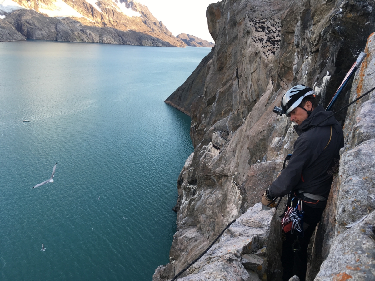
The Saltee Islands (Great and Little) are historically important in the context of Irish ornithology. Little Saltee’s fulmar population was established in the 1960s and has been the subject of study since its formation. The instigator of this long-term study, Professor David Cabot, is still heavily involved in seabird research carried out on the island. University College Cork has conducted GPS tracking studies on Northerm fulmars and Atlantic puffins at this site in recent years. The island became a SEATRACK study site in 2019, with deployment of GLS on northern fulmar and Atlantic puffin.
Site coordinator
Species
Sceilig Mhichíl (Skellig Michael), Ireland
51.771°N x 10.539°W

Skellig Michael, or Sceilig Mhichíl in Irish, is a tower of old red sandstone over 12km from the mainland and
standing at over 200m. The island is a UNESCO World Heritage site due
to the presence of a 6th century monastery famous for its beehive huts and precarious setting. European Storm petrels nest within stone construction of the beehive huts and drystone walls. Skellig Michael’s steep cliffs provide nesting habitat for Northern fulmars, Black-legged kittiwakes, and Common guillemots, while the steep slopes are dotted with the burrows of Atlantic puffins and Manx shearwaters. Its sister island, Little Skellig, is host to the largest gannetry in Ireland with over 35,000 breeding pairs.
There are around 4,000 breeding pairs of Atlantic puffins on Skellig Michael. Individuals tracked from this colony between 2010 and 2013 brought to light the extraordinary migration from Ireland to the Canadian coast after the breeding season. Skellig Michael will become a SEATRACK site in summer 2020, with GLS deployed on Atlantic puffins.
Site coordinator
Species
Rockabill, Ireland
53.597°N x 6.004°W
Rockabill comprises two tiny granite islets in the north Irish Sea 6.4 km east of the north Dublin town of Skerries. The land area is about 0.9 hectares but the majority is covered by the lighthouse and associated buildings. Three BirdWatch Ireland wardens are based on the island for the breeding season spanning late April to mid August.

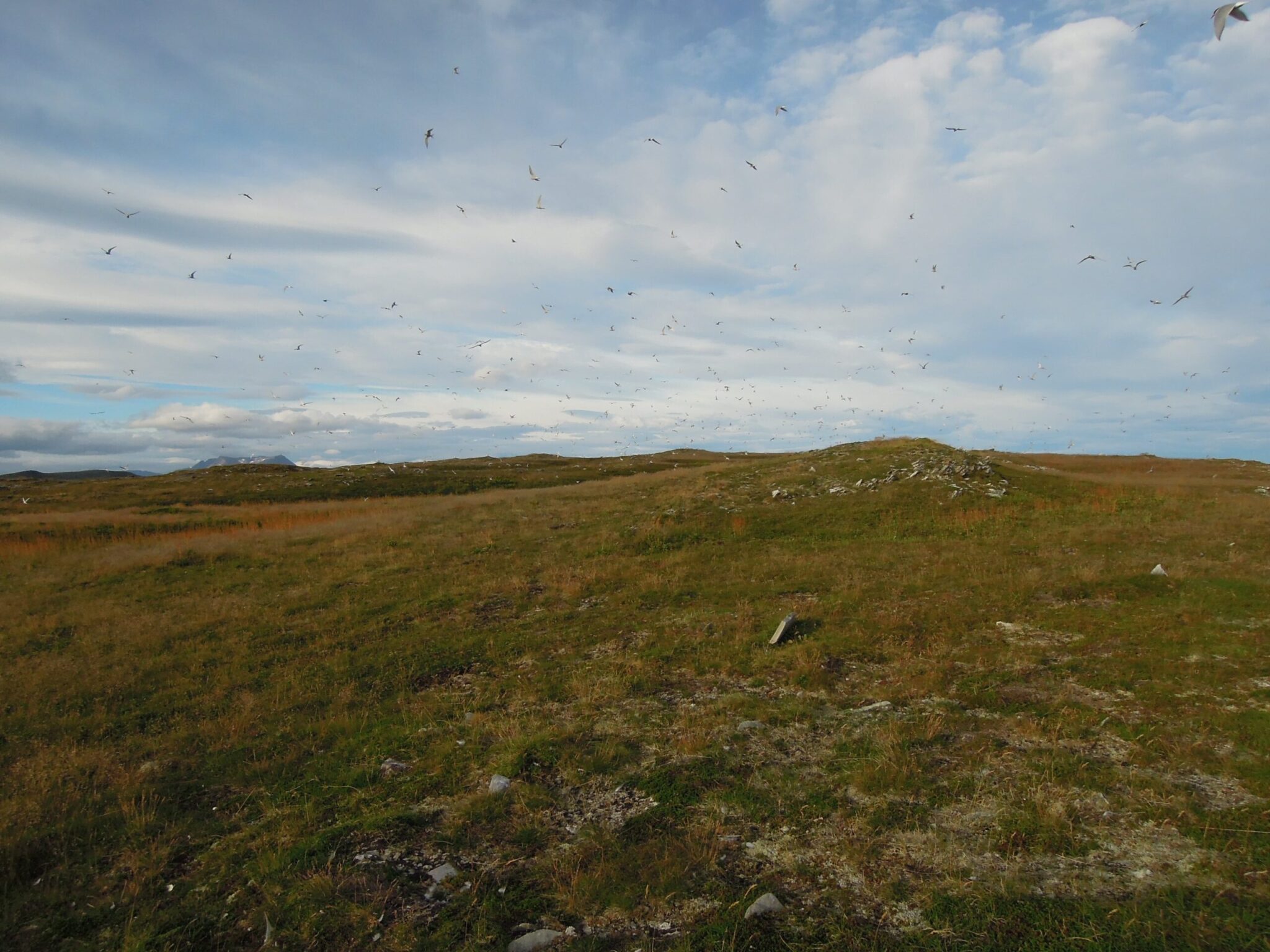
Rockabill is best known a tern colony supporting 80% of Northwest
Europe’s Roseate Tern population, currently about 1,600 pairs. They nest with ca. 2,000 pairs of common Terns and smaller numbers of Arctic Terns. In addition, the low cliffs hold up to 200 pairs of black-legged kittiwakes and 60-80 pairs of black Guillemots. Virtually all seabird pulli are ringed every year and the majority of the breeding populations are thus of known age.
The foraging ranges of breeding kittiwakes have been assessed using GPS loggers and of Roseate Terns using boat-based visual tracking. Prior to becoming a SEATRACK site, GLS loggers have been deployed (and retrieved) on both Black Guillemots and Roseate Terns. In 2019 we deployed GLS loggers on the kittiwakes for the first time.
Site coordinator
Species
Norway
Alkefjellet - Svalbard, Norway
79.585°N x 18.459°E

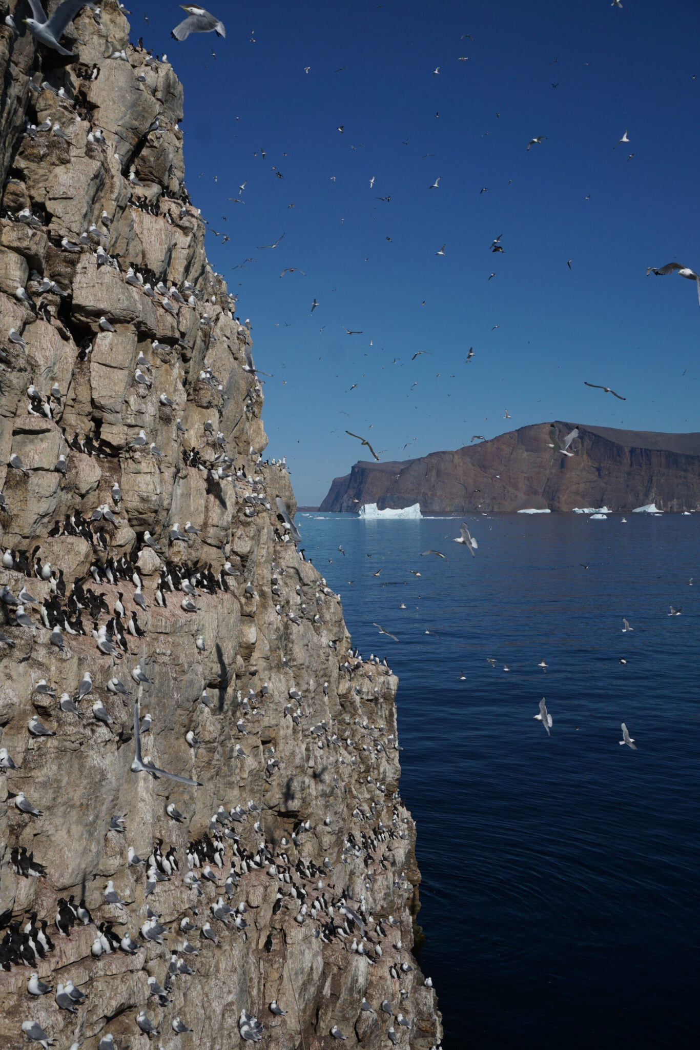
Alkefjellet is a s a several kilometer long, up to a one hundred meters high, steep cliff in Lomfjordhalvøya, Spitsbergen, Svalbard. Reflecting high productivity in nearby seas, Alkefjellet is home to thousands of seabirds, mainly Brünnich’s guillemots (ca. 100,000 individuals) and black-legged kittiwakes (>5000 individuals). Northern fulmars, glaucous gulls and black guillemots are also common breeders there.
Alkefjellet became a SEATRACK location in 2015 with GLS loggers being deployed on Brünnich’s guillemots, northern
fulmars and black-legged kittiwakes. Alkefjellet is the only site in East Svalbard where seabirds are studied. Alkefjellet became a SEATRACK location in 2015 with GLS loggers being deployed on Brünnich’s guillemots, northern fulmars and black-legged kittiwakes.

Site coordinator
Species
Anda, Norway

69.065°N x 15.170°E
Anda is a small island (0.15km2) located north of the Vesterålen archipelago in Nordland County, Norway.
Anda is an important breeding ground for Atlantic puffins, with around 15.000 breeding pairs.
Other species found breeding on Anda include Black-legged kittiwakes, European shags, Common guillemots, Razorbills, black guillemots, Herring gulls and Great black-backed gulls . There is also a few Common eiders, which attempt to breed at the island.
Due to its value as a breeding site for seabirds, the island has been protected as a nature reserve since 2002, and in 2013 it was designated a Ramsar site. From 15th of April, to 31st of July, access to the island is prohibited.
Being situated in between the edge of the continental shelf in the west and the shallow fjords in the east, the ocean around Anda thus provides diverse and reliable feeding conditions for the birds breeding in colony. The birds in this area do not depend on the larvae brought northwards by the coastal currents, but feed on local populations of sandeels in the adjacent fjords, as well as mesopelagic fish on the shelf edge. Anda has been a SEAPOP key site since 2005.

Population size is monitored for all seabird species and breeding success, diet, adult survival, and chick growth of puffin and kittiwake is monitored every year. Since 2009 kittiwakes has been instrumented with GLS loggers and since 2011 with GPS-loggers. The site became a SEATRACK locality in 2014 and loggers have since been deployed on puffins, kittiwakes and herring gulls.
Site coordinators
Species
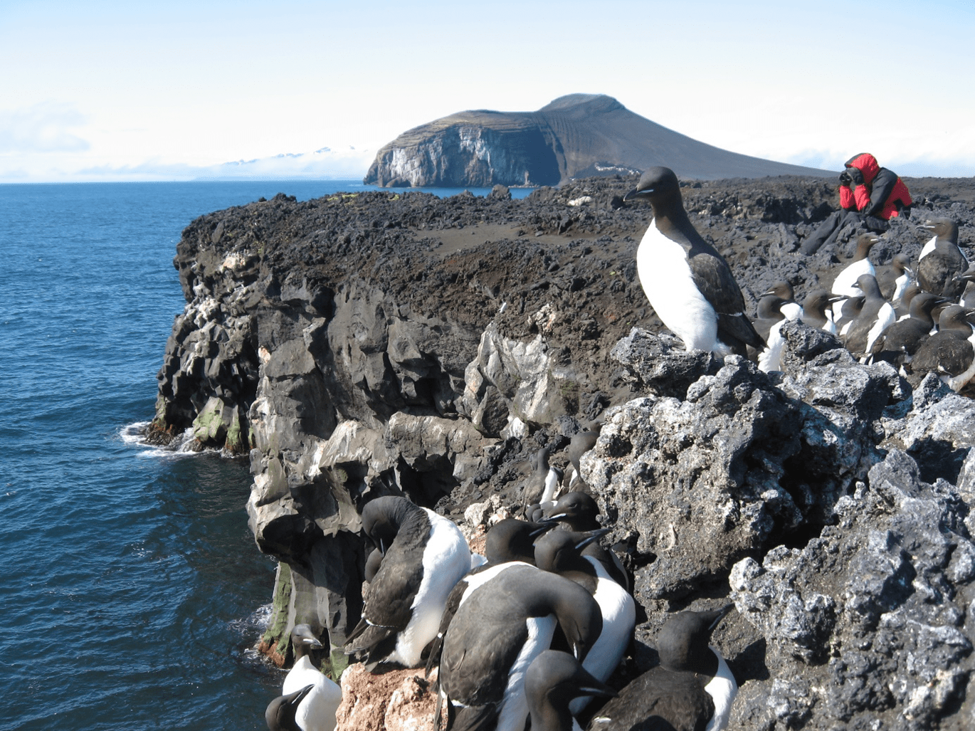
Bjørnøya (Bear Island) - Svalbard, Norway

74.503°N x 18.956°E
Bjørnøya is the southernmost island of the Svalbard archipelago. The island which has an area of 178km2 is located in the western part of the Barents Sea, approximately halfway between Spitsbergen and the North Cape.
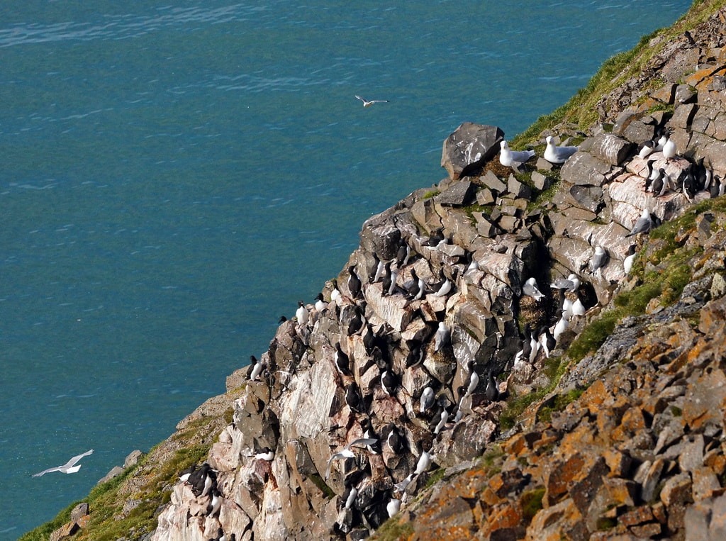
Seabirds have been monitored on Bjørnøya since 1986. It supports breeding populations of Northern fulmars (50,000–60,000 pairs), Glaucous gulls (2000 pairs), Black-legged kittiwakes (100,000 pairs), Little auks (10,000–100,000 pairs), Common guillemots (80,000 pairs), Brünnich’s guillemots (130,000 pairs) and Black guillemots (1000 pairs). The island became a nature reserve in 2003, and has been identified as an Important Bird Area (IBA) by BirdLife International.
Bjørnøya has been a SEAPOP keysite since 2005 and a SEATRACK locality since 2013, although several GLS studies have been carried out there earlier. Common guillemots and Brünnich’s guillemots have been instrumented there since 2007, great skuas since 2008, black-legged kittiwakes and little auks since 2009 and glaucous gulls since 2010.
Site coordinator
Species
Grindøya (Grindoya), Norway

69.635°N x 18.848°E
Grindøya, is a flat, wooded, 0.58 km² island in Tromsø municipality. It is possitioned in Sandnessundet between Tromsøya to the east, Kvaløya in vest and Håkøya in north. The island is a nature reserve and traffic is restricted during the breeding period from 1’st of May to the 30’th of June. Several seabird species breed on the island, amongst them; Common gulls, Herring gulls, Great black-backed gulls, Arctic terns and Common Eiders.
The Common eider population has been monitored and studied since 1985 but Grindøya became a SEAPOP key monitoring area in 2009 and a SEATRACK locality in 2014.
Site coordinator
Species
Hjelmsøya (Hjelmsoya), Norway
71.113°N x 24.732°E

Hjelmsøya is a 39 km2 mountainous island in Måsøy Municipality in Finnmark county, Norway. It lies west of the islands of Måsøya and Magerøya, north of Havøya and the mainland. There are two large nature reserves on the island: Hjelmsøystauren (4.4 km2), a large bird cliff in Staurfjellet on the northernmost part of the island, and Hjelmsøysandfjorden (1.3km2) a plant and seabird nature reserve with sand dunes surrounded by steeply sloped mountains.
Most of the seabird species breed in the Hjelmsøystauren nature reserve. Hjelmsøya holds the second largest Brünnich’s guillemot colony in Norwegian territory, 12 – 14 000 pairs, despite having been reduced from

120 000 pairs in the 1970’s. Up to 2000 pairs of Brünnich’s guillemot used to breed on the island in the early 90’s, but the colony has diminished and now few birds visit the colony without producing eggs or chicks. The breeding population of kittiwakes has been severely reduced as well, from its peak of 40 000 breeding pairs to approximately 1200 pairs in the year 2016. Now the most numerous species is the atlantic puffin which population has been estimated to exceed 80 000 pairs breeding at Staurfjellet.
The Hjelmsøya razorbill population is estimated to be 4000-5000 pairs but other breeding populations include arctic skua, great skua, common gulls, great black backed gulls, herring gulls, common eiders, greylag geese and black guillemots. White-tailed eagles are commonly observed on the island and regularly feed in the seabird colonies.
Seabird monitoring was initiated on Hjelmsøya in 1984 and today around 20 seabird species are regularly monitored. Most of these breed in Staurfjellet but European shags are monitored on a nearby island Lille-Karmøy, great cormorants in a larger area in western Finnmark and Atlantic puffins on the Gjesværstappan islands. Hjelmsøya became a SEAPOP key-site in 2005 and a SEATRACK locality in 2014 but kittiwakes were instrumented there as early as 2008 and guillemots in 2011.
Site coordinator
Species
- Common guillemots
- Atlantic puffins
- Herring gulls
- European shag [Currently there are no data available]
Hornøya (Hornoya), Norway
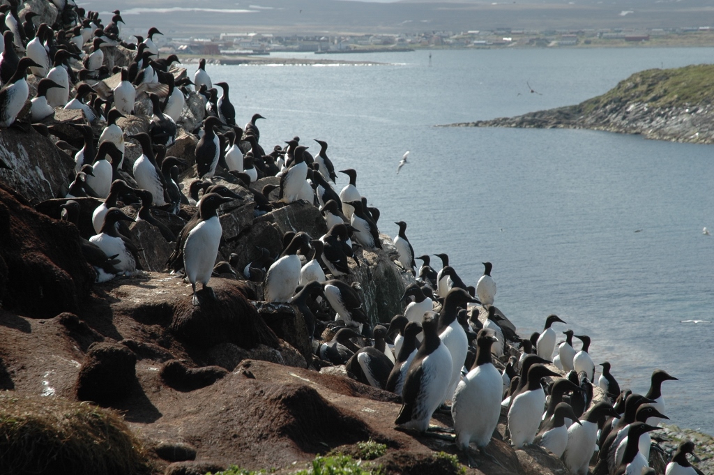
70.383°N x 31.150°E
Hornøya is a 65 m high, 0.4 km2 island in Vardø municipality in Finnmark county, Norway, about two km northeast of the town of Vardø, in the southern Barents sea region. It is a part of the Hornøya and Reinøya nature reserve established in 1983.
The bird cliff it self is on the west side of the island, where kittiwakes, razorbills, common guillemots, Brünnich’s guillemots, Atlantic puffins, and European shags breeed in the steep slopes. A few northern fulmars and black guillemots breed scattered around the island and where the landscape levels out herring gulls, great black-backed gulls, common eiders and greylag geese can be found breeding.

A seabird monitoring program was initiated in Hornøya in 1980 which was incorporated into SEATRACK in 2005 and in 2014 Hornøya became a SEATRACK location. Logger studies have been carried out on European shags as early as 2006, black-legged kittiwakes since 2008 and on both guillemot species since 2009.
Site coordinators
Species
Hornsund - Svalbard, Norway
77.000°N x 15.330°E
Hornsund is southwestern most fjord in Spitsbergen, Svalbard. It is 30 km long and 12 km wide at its widest with an average depth of 90 m. The surrounding water masses are made up of cold Arctic and warm Atlantic currents. The Hornsund area falls within the borders of the Sørspitsbergen Nasjonalpark and is protected by law.The Polish Stanislaw Siedlecki research station is the only one permanent research station in the area.
Hornsund hosts a large population of the little auk (ca 500 000 breeding pairs). Brünnich’s guillemots and black-legged kittiwakes can also be found breeding in small colonies within the fjord. Research activity is mainly focused on the little auks, and has been since 1960 but the current monitoring of breeding biology and foraging ecology in the colony at Ariekammen slope, was established in 2001.
Hornsund was established as a SEATRACK-locality in 2015, when logger deployment on little auks was initiated.

Site coordinator
Species
Horsvær, Norway
65.320°N x 11.630°E
Horsvær is divided into South- and North-Horsvær. The archipelago includes both flat islands with significant vegetation and rocky islets. The vegetation is typical for the coastal landscape in this region with different grass species. Meadowsweet is an important plant on several of the islands, especially on Buøya, where the meadowsweet meadow is the most important breeding habitat for lesser black-backed gull.
Horsvær was protected because of its seabirds, and the colony of lesser black-backed gull is important. In good years, up to 400 pairs breed in 7-8 sub-colonies have been counted although the numbers vary a lot from year to year. In 2013, there were only 18 nests in the entire colony. Horsvær is also a very important breeding area for many other gull species including common gull, herring gull and great black-backed gull. In addition, there is a significant cormorant colony in the middle of the archipelago where hundreds of pairs regularly breed.
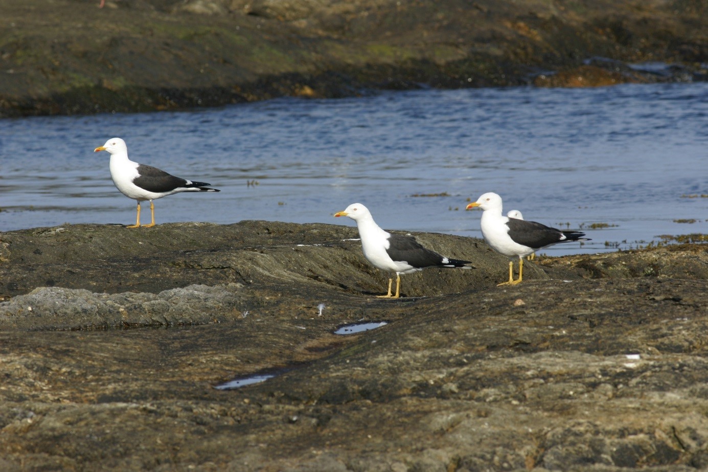
Detailed population studies of the lesser black-backed gull have been conducted annually since 2005. This includes a fieldwork period from June to the end of July to ring gull chicks. The fieldworkers collect data to calculate adult survival, clutch size, recruitment and breeding numbers of lesser black-backed gulls, as well as take diet samples. Numbers of nests of common gulls, herring gulls and cormorants are also monitored.
Site coordinator
Species
- Lesser black-backed gulls [Currently there are no data available]
Isfjorden - Svalbard, Norway

78.253°N x 15.508°E
Spitsbergen is the largest island in the Svalbard archipelago, with sparse vegetation except around the seabird colonies, Svalbard’s arctic climate is somewhat mitigated by warm Atlantic waters. 28 seabird species are
registered as regular breeders in Spitsbergen, the most numerous being: Little auks, fulmars, brünnich’s guillemots and kittiwakes.
Isfjorden has been a

SEAPOP key-site since 2005, for Brünnich’s guillemots and little auks but monitoring of kittiwakes was initiated in 2008.
GLS loggers have been deployed on seabirds in Isfjorden since 2008 but the area became a SEATRACK site in 2014.

Currently it’s only kittiwakes and Atlantic puffins being tagged in Isfjorden.
Site coordinator
Species
Jan Mayen, Norway
70,921°N x 8,718°W
Jan Mayen is a mountainous, 373 km2 volcanic island midway between Iceland and Spitsbergen. Its highest summit, Beerenberg, rises 2277 m above sea level and is partially covered by a glacier.
Jan Mayen is protected as a nature reserve (2010) and is home to a large number of seabirds of various species, the most numerous being Northern Fulmars, Brünnich’s guillemots and Little auks. The largest seabird colonies are found on the northeastern part of the island. Among other breeding seabird species are kittiwakes, glaucous gulls, great skuas, great black-backed gulls, herring gulls and eiders. Seabird colonies in Jan Mayen were mapped in 2010, and annual monitoring under the banner of SEAPOP was initiated in 2011. GLS loggers have been deployed on guillemots breeding on Jan Mayen since 2012.

That work was incorporated into SEATRACK in 2013, and in 2014, we also started deploying loggers on fulmars.
The areas accessible for effective work on seabirds are on the central part of Jan Mayen.
Guillemots are captured at Skrinnodden on the southern coast. This area is relatively young in geological terms, and the birds breed in small, scattered colonies along the black, ragged cliffs. Wind erodes the area, and drifting sand can change the features of the ledges from one year to the next.
Site coordinator
Species
Jarsteinen, Norway

59.150°N x 5.174°W
Jarstein is an rocky island located in Karmøy municipality in Rogaland county, Norway. It is a 0,266km2 nature reserve with 11 bird species regularly breeding, mostly seabirds such as european shag, great black-backed gull, lesser black-backed gull, herring gull, black-legged kittiwake and fulmar.
Site coordinator
Species
Kongsfjorden - Svalbard, Norway

78.900°N x 18.697°E
Kongsfjorden is located at the northwest Spitsbergen. It is a fjord, 26 km long and 6-14 km wide. The fjord is surrounded by tundra, steep mountains and glaciers. Ny-Ålesund is the only settlement in Kongsfjorden, and coal mining was the main activity before mid 1960’s. Nowadays research is the core activity, with several international research stations.

Seabirds have been monitored in Kongsfjorden since the early 1980s. Two bird sanctuaries, Kongsfjorden and Blomstrandhamna, protect the islets in Kongsfjorden, where approximately 2500 and 800 pairs of Common eider and Barnacle geese breed. Black-legged kittiwakes and Brünnnich’s guillemots are the most numerous species in the bird cliffs, with approximately 3000 and 1000 breeding pairs. Little auk, Arctic tern, Northern fulmar, Glaucous gull, Arctic skua, Great skua, Black guillemot, Atlantic puffin, Long-tailed skua and Long-tailed duck are also regular breeders in Kongsfjorden.
Kongsfjorden has been a SEAPOP keysite since 2005 and SEATRACK-locality since 2013. Black-legged kittiwake, common eider and glaucous gull are the three species included in SEATRACK. However, GLS studies were carried out for the first time in 2007 on Brünnich’s guillemots and barnacle geese. Black-legged kittiwakes have been instrumented since 2008, common eiders and arctic skuas since 2009, glaucous gulls, little auks and long-tailed skuas since 2010 and arctic terns since 2012.
Site coordinators
- Børge Moe (common eiders and black-legged kittiwakes)
- Kjetil Sagerup (glaucous gulls)
- Olivier Chastel (black-legged kittiwakes)
- Sébastien Descamps (Brünnich’s guillemots and little auks)
Species
Lemmingvær (Lemmingvaer), Norway
69.031°N x 16.905°E
– Description to be added
Site coordinator
Species
Loppa, Norway
70.358°N x 21.398°E
Loppa is an island in northwestern Finnmark county, in northern Norway. The island is 7,4 km long, 2,5 km wide and the highest peak, Rektind rises 274 m above sea level.This island provides a wide variety of habitats for breeding birds, from sheer cliffs at the western side, rocky shores at the northern and eastern side, and sand-dunes in the southern part.
Earlier the lowlands were farmland but are nowadays abandoned and grade into birch forest up to 100 m altitude, above which the vegetation is limited to ground-level flora.
In the steep cliffs of the western part of the islands several thousand puffins and razorbills breed as well as few hundred pairs of common guillemots. Further inland great skuas, arctic skuas common gulls, great black-backed gulls, herring gulls and lesser black-backed gulls breed.
Two subspecies of lesser black-backed gulls Larus fuscus intermedius and Larus fuscus fuscus can be found breeding there. In good years the Lesser Black-backed Gull colony, that is mostly situated in two subcolonies, one at Matmorstuva and one at Svarthellaren, can total up to 80 pairs. A large part of the island is a nature reserve.
Site coordinator
Species
- Lesser black-backed gulls [Currently there are no data available]
Lyngøy (Lyngoy), Norway
60.668°N x 04.749°E
Lyngøy is an island in the north of Tysnes municipality in Hordaland. The 62-da island is in Bjørnafjorden about 2.5 km from land. The site was established as a nature reserve for seabirds in 1987.
In Lyngøy, bird life is dominated by herring and lesser black-backed gulls. In the monitoring period 2009-2017, the breeding population of the former has varied between 320 and 380 pairs. For lesser black-backed gulls, here the southern subspecies L. f. intermedius, the population has varied between 80 and 120 pairs. Figures from 1979 show that large gulls also dominated the island, but that the lesser black-backed gulls were then in the majority with 110-130 pairs (the population of herring gulls was estimated to be 60-95 pairs). Of other bird species, we find great black-backed gulls, common gulls, greylag geese, eiders, oystercatchers and red-breasted mergansers. Of passerines, the island has rock-, and meadow pipits and hooded crows.
Birds have been ringed on Lyngøy since the 1960s, but totalled only a few hundred during the first three decades. In the 1990s and 2000s, the effort was intensified, and >2000 chicks were ringed on the island. In total, 1502 herring gulls, 1286 lesser black-backed and 53 great black-backed gulls (all pulli) were ringed before ringing in SEAPOP was initiated in 2010.

Site coordinator
Species
Mandal & Lindesnes, Norway
58.008°N x 7.368°W
Seabird research on behalf of SEAPOP and SEATRACK in Vest-Agder is mainly carried out on five islands in the archipelago off the coast off Mandal municipality and on the island of Rauna, Farsund municipality. The islands in Mandal are Store Slettingen, Lille Slettingen, Storøy, Østre Klovholmen and Vestre Klovholmen. Combined, the Store – and the Lille Slettingen have an areal of 0.1 km2, the Østre- and Vestre Klovholmen 0.03 km2 and Storøy 0.2 Km2. The islands of Slettingen and Klovholmen have been protected as a nature reserves since 1980.
The avifauna on these islands is dominated by gulls, most numerous of them being the lesser black-backed gulls of the sub-species, Larus fuscus intermedius and herring gulls. Other species that can be found breeding on the islands include; greylag geese, common eiders, red-breasted mergansers, oystercatchers, great black-backed gulls and common gulls.
Mandal and Lindesnes has been a SEAPOP locality since 2008 and became a SEATRACK site in 2014 but GLS loggers were deployed on lesser black-backed gulls in earlier years.

Site coordinator
Species
Runde & Ålesund (Runde & Aalesund), Norway
62.436°N x 05.874°E
GLS deployment are currently being carried out at two sites in Møre & Romsdal county on the northwest coast of Norway. Atlantic puffins on the island of Runde and black-legged kittiwakes within the city of Ålesund.
Runde
Runde is a small island in Møre og Romsdal on the northwest coast of Norway. The island, on which thousands of seabirds nest, has an area of 6,2km² and is the southernmost bird cliff in Norway.
The island supports a breeding population of Northern gannets (4000 pairs), European shags (350 pairs), black-legged kittiwakes (400-500 pairs), great skuas (100 pairs), Atlantic puffins (50 000-60 000 pairs), common guillemots (1000-1500 pairs), black guillemots (40-50 pairs) and razorbills (300-400 pairs). Herring gulls, lesser black-backed gulls, great black-backed gulls and common gulls on the island can also be found breeding on the island. Runde, which has been identified as an Important Bird Area (IBA) by Birdlife International, was protected by law in 1957 and in 1979 a bird sanctuary was established on the island. Seabirds have been monitored in Runde intermittently from 1956 but the current annual monitoring scheme was established in 1972.
Runde has been a SEAPOP keysite since 2007, and a SEATRACK locality since 2014 when GLS deployment on Atlantic puffins was initiated.

Ålesund
Ålesund is a city, of approximately 45 000 inhabitants, in Möre og Romsdal county on the northwest coast of Norway. Since the 1930s kittiwakes have nested in different parts of the city. At its peak around 2000 pairs could be found breeding in various subcolonies around the city but currently the population is estimated to be around 1500 pairs.
The sub-colony in Steinvågsundet on Aspøya, where monitoring and GLS deployment are being carried out, counts around 700 pairs and is located in a rock wall above a street behind a fish landing site. This colony was first discovered by local birders in the late 1990s and has been in constant growth ever since. Steinvågsundet became a SEAPOP keysite in 2011, and a SETRACK locality in 2014 although GLS loggers have been instrumented on kittiwakes there since 2013.

Site coordinators
Species
Røst (Rost), Norway

67.447°N x 11.910°E
The Røst municipality is a cluster of many small islands forming the south-western tip the Lofoten archipelago and situated approximately 100 km west of mainland Norway. The total areal of these islands is 10.4 km².
The largest island in the Røst archipelago, Røstlandet, houses a small fishing village with approximately 550 inhabitants and a wetlands nature reserve established in 1997. South west of Røstlandet lies the Røst Islands Landscape Protection Area covering 70 km². It was established in
2002 and became a RAMSAR site in 2011. It includes the magnificent bird-cliffs of Vedøy, Storfjellet, Ellefsnyken, Trenyken and Hernyken and the famous Skomvær lighthouse farthest out. Ellefsnyken, Trenyken and Hernyken further comprise the Nykan Nature Reserve, also established in 2002. Røst is an outpost surrounded by the Norwegian Sea, but the archipelago stands on the shelf in shallow waters with hundreds of small islets and skerries and strong tidal currents.
Seabirds have been studied annually on Røst since the late 1950s, which has resulted in some of the longest time-series of seabird demography in Norway. The monitoring on Røst was integrated as a SEAPOP key site from 2005. GLS studies were started in 2006 (shags), 2008 (kittiwakes) and 2012 (puffins) and continued in SEATRACK from 2014. Current research and monitoring encompasses 16 species, of which 13 are considered key species within the SEAPOP program.
Site coordinator
Species
Selvær (Selvaer), Norway
66.585°N x 12.229°E

Selvær is a small cluster of islands, housing a small fishing village of 50 inhabitants, in the north east part of Træna municipality in Nordland. It’s one of the most remote places off the coast of Helgeland, 33 km from the nearest mainland and slightly above the Arctic Circle. Selvær consists of several hundred islets and islands, but only three are inhabited by people and connected by roads. These house one of the largest colonies of common eider in Nordland, 200-300 pairs that can be found breeding in small man-made shelters in an area of around 0,4 km2.
Selvær is not protected under any specific law nor is it a part of a protected area although several important nature types can be found in the archipelago. Several bird species can be found breeding there in addition to the common eider, e.g. greylag goose, black guillemot, black-legged kittiwake, herring gull, great black-backed gull, common snipe, house sparrow, thrushes, warblers and more. In May, every year, thousands of barnacle geese spend a month fuelling up at Selvær before heading to Svalbard.
Selvær became a SEATRACK locality in 2016.
Site coordinator
Species
Sklinna, Norway
64.740°N x 10.770°E
Sklinna is an archipelago within municipality of Leka, approximately 40 km off the mainland coast. It consists of a number of low, small islands and islets with sparse vegetation, the largest one being Heimøy. The archipelago became nature reserve, with an areal of 5.9 km2, in 2003 and became a Ramsar-site in 2011.

Sklinna is home to one of the world’s largest breeding populations of European shags, where, in favourable years, over 3000 pairs can be found breeding. Common and black guillemots can be found breeding on some of the islands as well as razorbills, Atlantic puffins, cormorants, common eiders, herring gulls and Great black-backed gulls. Common gulls, lesser black-backed gulls, northern fulmars and European storm petrels can, intermittently, be found breeding in low numbers.
Seabird monitoring was initiated on Sklinna in the early 1980’s and was established as a SEAPOP site in 2007 and a SEATRACK site in 2014 although GLS loggers have been deployed on European shags since 2008 and common guillemots since 2011. Since 2011, after the disappearance of the breeding population in Sklinna, kittiwakes have been monitored at the colony in Sør-Gjæslingan approximately 50 km south of the archipelago.
Site coordinator
Species
Russia
Gorodetskye ptich`i bazary (Cape Gorodetskiy), Russia

69.583°N x 32.937°E
Cape Gorodetsky is located in the south-east coast of the Rybachiy peninsula (western Murman) and spans about 7 km. Seabirds have been monitored at Cape Gorodetsky since 2000. It supports breeding populations of black-legged kittiwakes (25,000-50,000 pairs), common guillemots (300-1,500 pairs) Brünnich’s guillemots (1,400 pairs), cormorants (50-200 pairs), black guillemots (about 100 pairs), herring gull (about 50 pairs) and razorbill (about 50 pairs). The northernmost part of the cliff became a nature reserve in 2014. GLS studies were initiated in 2014 with deployment on common guillemots and Brünnich’s guillemots.
Site coordinator
Species
Mys Krutik (Cape Krutik), Russia

69.151°N x 35.948°
Cape Krutik is located in the central part of the northern coast of the Kola peninsula (central Murman). It spans about 0,6 km. Seabird monitoring was initiated in 1999. Approximately 2,000-4,500 pairs of black-legged kittiwakes can be found breeding there as well as 50-500 pairs of common guillemots, 20-200 pairs of Brünnich’s guillemots, black guillemots, herring gulls and razorbills. Colony has no protective status. Logger studies were first initiated in 2009 on kittiwakes but the site became a SEATRACK locality in 2014.
Site coordinator
Species
Karskiye Vorota (Kara Gate), Russia
77.593°N x 55.021°E
The Kara Gate colony is located on the southern part of the South Island of Novaya Zemlya Archipelago and spans about 9 km. Seabirds have been monitored at Kara Gate since 2014. It supports breeding populations of black-legged kittiwakes (3.000-3.500 pairs), common guillemots and Brünnich’s guillemots (a total of approx. 60000 individuals), glaucous gulls (approx. 10 pairs). GLS studies were first initiated in 2015 with deployments on kittiwakes and Brünnich’s guillemots.

Site coordinators
Species
Oranskie Ostrova (Oranskie Islands), Russia

77.069°N x 67.642°E
Oranskie Islands is a group of several small inshore islands just north off northern tip of Northern Island of Novaya Zemlya Archipelago. The islands are at the very border between Barents and Kara seas, but the area is influenced by relatively warm Barents Sea waters. The SEATRACK site is located on the Eastern Bolshoy Oransky Island where the cliffs are not too tall so birds can be caught.
The site is located within the Russian Arctic National Park established in 2009.

The islands themselves are not inhabited by humans, but remnants of early hunting activity are visible. At the nearby Zhelania Cape, situated at the northeastern-most tip of Northern Island a manned weather station was operated as well as a military base but both were closed down in the 1990s. Currently the only human activity in the area consists of the operations of the Russian Arctic National Park, during the summer months.
On Oranskie Islands; Brünnich’s guillemots, black-legged kittiwakes, glaucous gulls, black guillemots, Atlantic puffins and great skuas can be found breeding. Seabirds are not monitored regularly at the site and to date no other research is being conducted there. The islands are visited from time to time by tourist vessels and some intermittent monitoring of walrus numbers are carried out there.
Loggers were first deployed at the Oranskie Islands as a part of the SEATRACK pilot study in 2013, the site is however not easily accessible due to its remoteness thus annual visits cannot be guaranteed.
Site coordinators
- Ivan Mizin
- Previously: Maria Gavrilo
Species
Zaliv Russkaya Gavan (Russkaya Gavan), Russia
76.221°N x 62.580°E
The Bogatiy island colony is located on a small island in Russkaya Gavan Bay in the northern part of the Novaya Zemlya Archipelago. Seabirds have been monitored at Russkaya Gavan since 2016. It supports breeding populations of black-legged kittiwakes (2.500-3.000 pairs), Brünnich’s guillemots (approx. 10000 individuals, glaucous gulls (approx. 5 pairs), black guillemots (several pairs), common eider (approx. 20 nests) and Arctic tern (15-20 pairs). GLS studies were initiated in 2019 with deployment on kittiwakes.

Site coordinators
Species
- Black-legged kittiwakes
- Brünnich’s guillemots [Currently there are no data available]
Sem' Ostrovov (Seven Islands), Russia
68.748°N x 37.570°E

Sem’ Ostrovov or the Seven Islands archipelago is made up of a number small Islands ranging from 0,07 to 2,6 km2, located 1-3 km off the eastern coast of the Kola Peninsula.
Seabirds found in the archipelago include Northern gannets (200-300 pairs), cormorants (100 pairs), European shags (200-300 pairs), Great skuas (20 pairs), Arctic skuas (100-150 pairs), Great black-backed gulls (500-800 pairs), Herring gulls (500-800 pairs), Common gulls (100 pairs), Kittiwakes (10,000-25,000 pairs), Common guillemots (15,000-20,000 pairs), Brünnich’s guillemots (2,000-3,000 pairs), Atlantic puffins (3,000-5,000 pairs), razorbills (300 pairs) and black guillemots (200-400 pairs).
The islands became a natural reserve in 1938 and monitoring has been carried out ever since. The archipelago became a SEATRACK locality in 2015.

Site coordinator
- Ekaterina Tolmacheva
Species
- Atlantic puffins
- European shags [There are no data currently available]
Solovetskiye Ostrova (Solovetsky archipelago), Russia
65.048°N x 35.786°E

Onega Bay is the largest and the southernmost of the bays in the White Sea, located between 63°50` – 65°13` N and 34°50` – 37°40` E. The length of the bay from the north-west to south-east is about 175 km, maximum width – about 100 km. The bay area is approximately 12.3 thousand square kilometers and the total number of islands exceeds one thousand, most of which smaller than 0.1 km2. Vegetation communities are similar to the regions situated further north, such as elfin woodlands and marine tundra, and include pine-birch and spruce-birch forests.
Some of the islands are protected by three nature reserves and have been registered as Important Bird Area and Ramsar site “Islands in Onega Bay, White Sea”.
In 1987 the large-scale counts of seabirds on Solovetskiy Islands and survey of the islands located in the bay outside the archipelago was launched. Seabird numbers are monitored annually on the Solovetskiy Islands and on the adjacent archipelagoes within the bay but due to the size of the area and number of island within it only some islands can be surveyed each year.
The breeding population of common eiders is estimated to be 4300-4500 pairs, herring gull – 3500-3700 pairs, Lesser black-backed gull – 2200-2400 pairs, arctic Tern – 27000-28000 pairs and common gull – 3500-3700 pairs.
The migration of Lesser Black-backed gulls using satellite transmitters was studied in 2009. Onega Bay has been a SEATRACK locality since 2014.
Site coordinator
Species
Zemlya Frantsa-Iosifa (Franz Josef Land), Russia

80,338°N x 52,818°E
Deployments on behalf of SEATRACK in Franz Josef Land archipelago are carried out at three locations; Cape Flora on Northbrook Island and Tikhaya bay and Rubini Rock on Hooker Island. The study sites are all located within the Franz-Josef Land state federal wildlife reserve (zakaznik) established in 1994, and managed by the Russian Arctic National Park since 2011.
Cape Flora, at the southwestern most tip of Northbrook Island (250 km2) is a historical site, visited by most of the early explorers. Cape Flora supports one of the largest seabird colonies in archipelago with breeding populations roughly estimated at some 50000 pairs for Brünnich’s guillemots, over 1000 pairs for Little auks, some 10000 pairs for Black-legged kittiwakes, some tens of pairs for Black guillemots and some 50 pairs for Glaucous gulls. Seabirds have been monitored at Cape Flora intermittently since the 1980s. Cape Flora was chosen as a pilot site for SEATRACK in 2013. Black-legged kittiwakes have been instrumented there since 2013, Brünnich’s guillemots and glaucous gulls since 2014. All three species at Flora Cape are also sampled for ARCTOX project on circumpolar contaminant study. Kittiwakes are sampled for circumpolar comparative CORT study.

Tikhaya Bay and Rubini Rock located on Hooker Island (500 km2) in the very center of the archipelago, are amongst the best known seabird colonies in the Franz-Josef Land. Tikhaya Bay was first inhabited by humans during the wintering of Georgiy Sedov’s expedition in 1913/14, and later, with the establishment of a polar weather station in 1929, it became a central hub for scientific exploration of the archipelago. First population estimates of seabirds in Rubini Rock were carried out 1930. Since then, seabirds have intermittently been monitored on Rubini Rock, and studies of little auk ecology carried out in Tikhaya Bay. Rubini Rock supports large and diverse seabird colonies. It is estimated that some 15000 pairs of Brünnich’s guillemots, 1000 pairs of little auks, 10000 pairs of black-legged kittiwakes, 30 pairs of Glaucous gulls, some tens of pairs of black guillemots and less than 50 pairs of northern fulmars breed there. Larger separate colony of little auks stretches along the rocky slopes of Sedov Cape on the opposite coast of Tikhaya Bay.Tikhaya Bay was chosen as a pilot site for SEATRACK in 2013 and loggers deployed on Brünnich’s guillemots, black-legged kittiwakes and little auks but later deployments were limited only to little auks.
Site coordinator
Species
The Faroe Islands
Føroyar (Faroe Islands), The Faroe Islands
61.950°N x 6.798°W
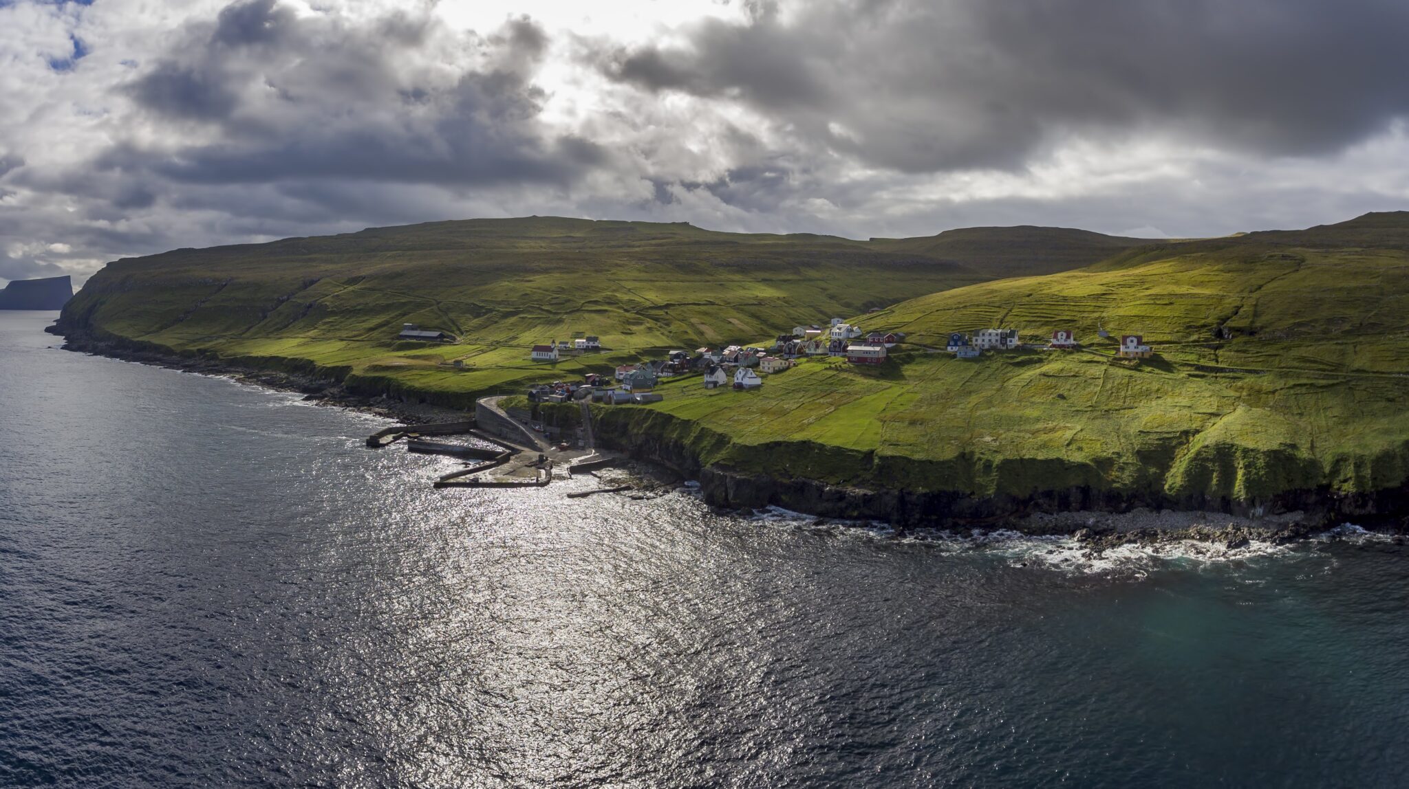
The Faroe Islands are situated in the North-East Atlantic and consists of 18 islands and approx. 800 islets and skerries with a total area of 1399 km2. With 1117 kilometers of coastline, much of it cliffs, and surrounded by productive seas the Faroes has become home to large populations of various species of seabirds.

The Faroe Islands became part of the SEATRACK in 2014. Originally 8species were included in the tagging scheme: Atlantic puffin, black-legged kittiwake, common guillemot, Northern fulmar, European shag, lesser black-backed gull, herring gull and the common eider. But because of the required effort the European shag was dropped already after the first year followed by the lesser black-backed gull and Herring gull the following year and it was decided to focus on the 5 species Atlantic puffin, black-legged kittiwake, common guillemot, Northern fulmar and the common eider.
The main tagging areas on the Faroes are Skúgvoy (Atlantic puffin and black-legged kittiwake), Mykines (Northern fulmar), Sandoy (common guillemot) and Kirkjubøhólmur (common eider).
Site coordinators
Species
- Atlantic puffins
- Black-legged kittiwakes
- Common eiders
- Common guillemots
- Lesser black-backed gulls [There are no data currently available]
- Northern fulmars
United Kingdom
Eynhallow, United Kingdom
59.142°N x 3.115°W

Eynhallow is a small uninhabited island within the Orkney Island group off the north of Scotland. It has an area of 0.75 km2, and is located in a 3 km wide channel between the larger islands of Mainland Orkney and Rousay. There are remains of a Norse church on the island, and evidence of regular inhabitation until the mid 1800’s. The island consists of low lying rough grassland and moorland, which is grazed seasonally by sheep, with steeper cliffs on its western side. During the late 1800’s and early 20th century, the island was used for sport shooting and as a holiday retreat by a local estate owner. From the 1930’s, the owners managed the island as an informal bird sanctuary. Orkney Island Council purchased Eynhallow in the 1980’s and the University of Aberdeen has maintained the one remaining house on the island as a seasonal field base for harbour seal and fulmar studies.

The small fulmar colony on Eynhallow has been monitored since 1950. These studies followed the early expansion of this species at Orkney sites, and were facilitated by the birds use of accessible low lying cliffs, old buildings and walls on the island as nest sites. At its peak in the mid-1980s the Eynhallow study colony contained over 200 nests, at a time when the total Orkney population was around 84,000 pairs. More recently, numbers have declined and only 75-100 nests are occupied each year.
Other seabirds breed on the island, but numbers are small and are not closely monitored. These include Puffins, Black Guillemots, Arctic Tern, Great Black-backed Gull, Common Gull, Arctic Skua and Great Skua.
Individual-based studies based upon colour-ringed fulmars have been carried out since 1950. GLS studies were initiated in 2006, resulting in recovered data from >100 individuals, in many cases for multiple years. GPS tracking data during incubation and chick rearing was also conducted on smaller samples of birds between 2009 and 2012.
Site coordinator
Species
Fair Isle, United Kingdom
59.541°N x 1.622°W
Fair Isle is a small island, just three miles long and a mile wide, lying between Orkney and Shetland in the far north of the United Kingdom. Britain’s remotest inhabited island is home to around 50 people, whose jobs include crofting, art and crafts (including producing the famous Fair Isle knitwear) and work in tourism. It is also the location of the Fair Isle Bird Observatory, which has been studying the Isle’s birds since 1948, as well as providing accommodation for visitors to the Isle.
Although famous as a site to witness migration and find rarities (over 30 firsts for Britain have been found on the Isle), the Isle is also home to large numbers of breeding seabirds. Significant declines of several species have been recorded in recent decades, but in the summer, visitors cannot fail to notice the increasing population of Great Skuas (known locally as Bonxies), with around 500 pairs now nesting amongst the heather and grass, predominantly in the north of the island. Around the cliffs and coasts there are also around 32,000 pairs of Fulmars, 4,000 pairs of Gannets, 21,000 Guillemots, 7,000 Puffins, 2,000 Razorbills and 200 pairs of Shags as well as smaller numbers of , Arctic Terns, Storm Petrels, Black Guillemots, Arctic Skuas, Herring, Great Black-backed, Lesser Black-backed and Common Gulls.
Fair Isle’s designations include Special Area of Conservation (SAC), Special Protection Area (SPA), Site of Special Scientific Interest (SSSI), Demonstration and Research Marine Protected Area (MPA) and National Scenic Area (NSA) as well as holding a Council of Europe Diploma.
Site coordinator
Species
- Atlantic puffin [Currently there are no data available]
- Common guillemot [Currently there are no data available]
Isle of May, United Kingdom

56.186°N x 2.558°W
The Isle of May, within the Isle of May National Nature Reserve since 1956, is the southernmost SEATRACK locality. It lies on the east coast of Scotland in the entrance to the Firth of Forth, approximately 8 km off the coast of mainland Scotland. The 0.57 km2 island is 1.8 km long and less than half a kilometer wide. The island is owned and managed by Scottish Natural Heritage. The island is characterized by a low lying and rocky eastern coast, and a west coast dominated by high cliffs. Although only 0.57 km2, it is of national and international importance for its seabird and seal colonies. During the height of the breeding season, over 200,000 seabirds of 14 species nest on the island, including puffins, black-legged kittiwakes, razorbills, guillemots, shags, fulmars, oystercatchers, eider ducks, and various species of terns and gulls.
Isle of May, which became a SEATRACK locality in 2014, is one of the four strategic seabird-monitoring sites in Great Britain, the others being Fair Isle, Canna and Skomer. Seabird research started on the Island in 1966 and has increased dramatically to date and since 2000 an intensive study focusing on the link between fish stocks and seabirds is being carried out. Extensive GLS studies have been carried out on the island where Atlantic puffins, black-legged kittiwakes and razorbills have been instrumented since 2007, European shags since 2009 and common guillemots since 2011.

Site coordinator
Species
Isle of Canna, United Kingdom
57.059°N x 6.559°W
Canna is a small island (8kmx2km) on the west coast of Scotland. Much of its shoreline is made up of steep cliffs of basalt rock, which on the north side of the island rise to 200m. Below the main cliffs lies
a raised wave cut platform, covered in boulder screes, and below it the current sea cliff, roughly 20m high. This is where the bulk of Canna’s seabirds breed. Seabird numbers peaked in the late 1980s to early 1990s since w
hen there have been some major declines. Recently, partly as a result of a rat eradication project some of these declines have been reversed. Currently Canna supports 130 pairs of northern fulmar, 440 pairs of European shag, 1,500 pairs black-legged kittiwake, 2,000 pairs of common guillemot, 500 pairs of razorbill and 2,000 Atlantic puffin. There are also small colonies of gulls and great skuas.
The island’s seabirds have been monitored annually since 1969 by members of the Highland Ringing Group, one of the longest running seabird monitoring programmes conducted solely by amateur volunteers. In 2019 Canna became a SEATRACK location with geolocators being deployed on northern fulmars, black-legged kittiwakes and common guillemots. Data from geolocators, sourced by Marine Scotland, and deployed on Canna since 2015 have been shared with SEATRACK.

Site coordinator
Species
Shiant Isles, United Kingdom
57.899°N x 6.358°W
– Description to be added
Site coordinator
Species
- Atlantic puffin [Currently there are no data available]
- Common guillemot [Currently there are no data available]
Treshnish Isles, United Kingdom

56.497°N x 6.418°W
This group of eight terraced, Tertiary basalt islands (c.128 ha), together with three smaller vegetated islets and numerous skerries, is situated at its closest 3 km west of Mull, N.W. Scotland. Uninhabited by humans since 1834 and livestock since the 1980’s, the Isles are of importance for breeding seabirds (over 23,900 pairs), which includes Storm Petrels (10,228 pairs), large numbers of auks (predominately coomon g uillemot at 10,495 individuals), Manx Shearwaters (1,992 pairs) and other common breeding seabirds. To coincide with the most profitable period for seabird monitoring and optimum weather and day length, Treshnish Isles Auk Ringing Group generally visit the Treshnish Isles in the last week of June to undertake an annual seabird census and ringing of specific seabird colonies.
The Treshnish Isles became a SEATRACK location in 2019 with GLS loggers being deployed on Atlantic Puffins and common guillemots.

Site coordinator
Species
- Atlantic puffin [Currently there are no data available]
- Common guillemot [Currently there are no data available]
Species
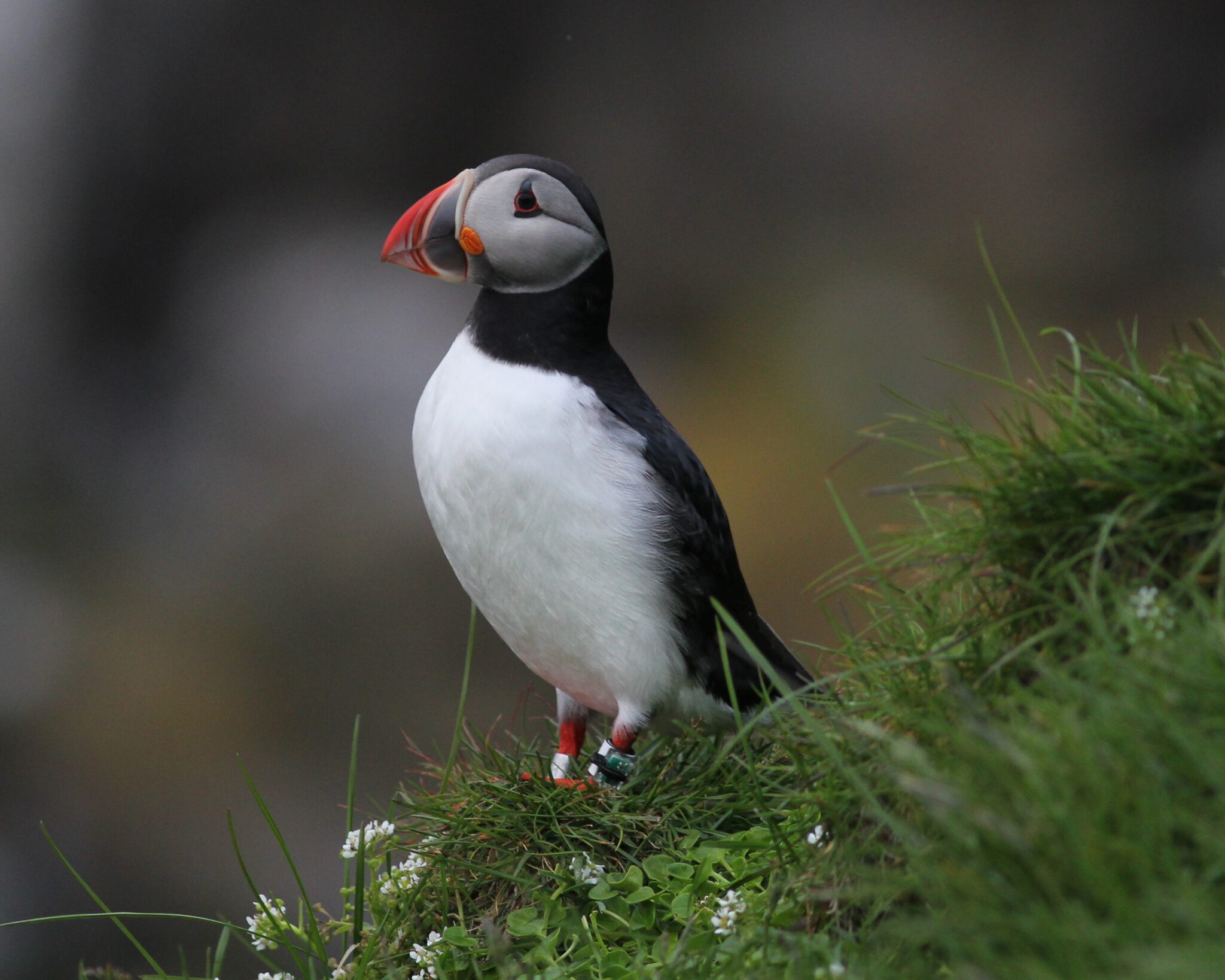
Atlantic puffin (Fratercula arctica)
Atlantic puffins (Fratercula arctica), representing one of four pelagic diving species within the scope of the project, are being instrumented with GLS loggers at 20 SEATRACK localities. Puffins are abundant in the North Atlantic but rapid declines across its European range in recent years have caused the IUCN to classify the species as “vulnerable” on its 2015 red list. Although puffins are the most numerous seabirds along the coast of the Norwegian mainland they are classified as vulnerable on the Norwegian red list due to a population decline. In 2019, SEATRACK also started deploying GLS loggers on puffin chicks at three locations (Hornøya, Anda and Isfjorden).
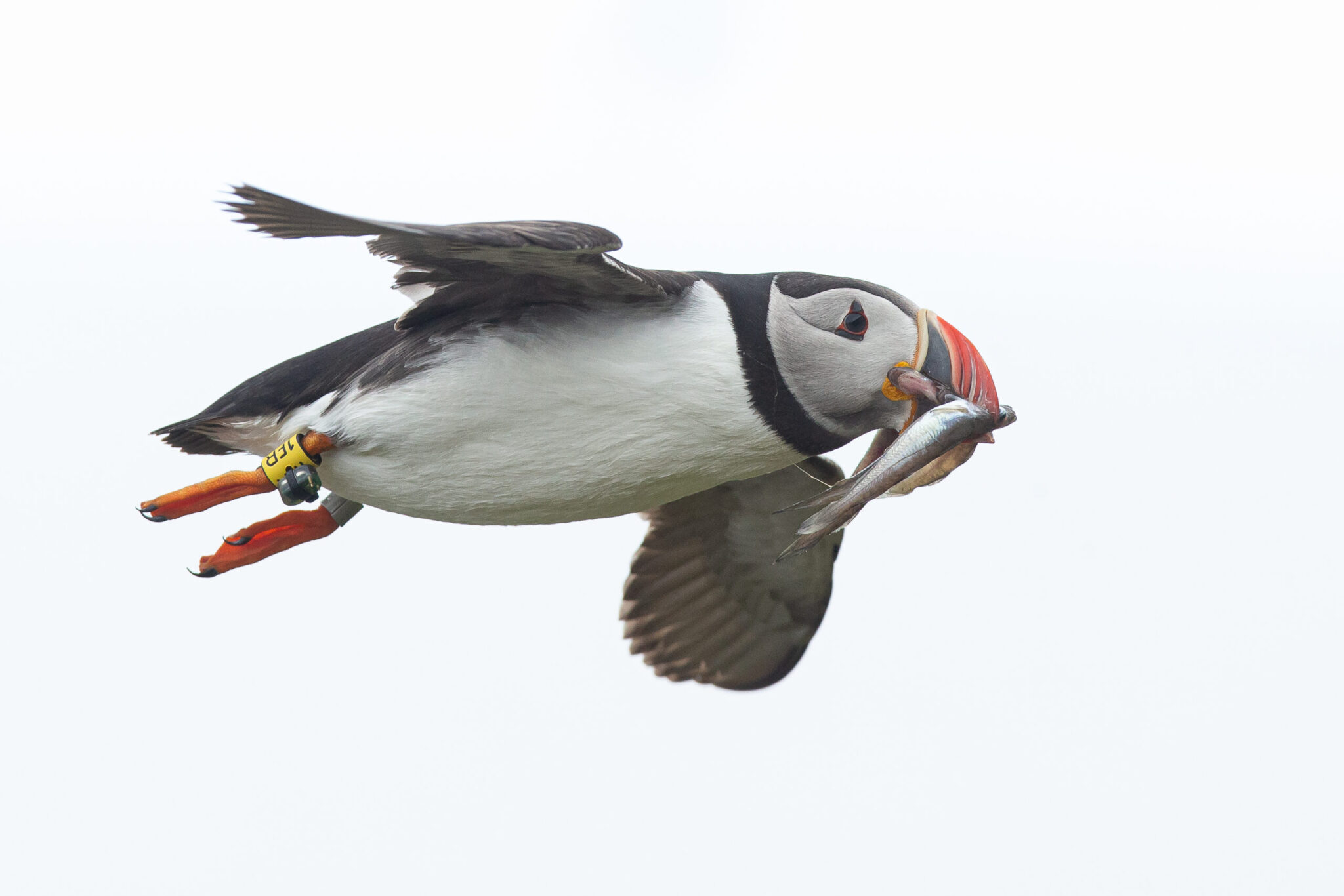
The Atlantic Puffin is a member of the auk family and widespread in the North Atlantic Ocean where the largest populations can be found in in Iceland and Norway. It has a black crown and back, pale grey cheeks and white underparts. Its broad, boldly marked red and black beak and orange legs contrast with its plumage. It molts while at sea in the winter and some of the bright-colored facial characteristics are lost.
Outside the breeding season puffins do not come on land. They are piscivores and great divers, mainly preying on a variety of smaller fish including capelin, sand-lance, herring, small gadoids and hake.

Locations
- Anda, Norway
- Bjørnøya – Svalbard, Norway
- Fair Isle, United Kingdom [There are no data currently available]
- Føroyar (Faroe Islands), Faroe Islands
- Grímsey (Grimsey), Iceland
- Hjelmsøya (Hjelmsoya), Norway
- Hornøya (Hornoya), Norway
- Isfjorden – Svalbard, Norway
- Isle of May, United kingdom
- Little Saltee, Ireland
- Papey, Iceland
- Runde & Ålesund (Runde & Aalesund, Norway
- Røst (Rost), Norway
- Sem’ Ostrovov (Seven Islands), Russia
- Shiant isles, United Kingdom [There are no data currently available]
- Skellig Michael, Ireland
- Sklinna, Norway
- Treshnish Isles, United Kingdom [There are no data currently available]
- Vestmannaeyjar, Iceland
- Witless Bay, Canada
- All sites
Black-legged kittiwake (Rissa tridactyla)
Black-legged kittiwakes (Rissa tridactyla), representing one of three pelagic surface feeding species within the scope of the project, are being instrumented with GLS loggers at 25 SEATRACK localities. Although being classified as endangered along the coast of mainland Norway, near threatened in Svalbard and decreasing population trends over much of its range the Black-legged kittiwakes are wide spread and abundant in the North Atlantic and considered “least concern” by the IUCN. In 2019, SEATRACK also started deploying GLS loggers on black-legged kittiwake chicks at two locations (Anda and Kongsfjorden).

The black-legged kittiwake can be found breeding along coastlines of the north Pacific and Atlantic oceans. It has a white head and body, grey back with black wing tips, the legs are black and the bill yellow.
Black-legged kittiwakes feed predominantly on marine invertebrates and fish. At sea during the winter they have also been known to feed on planktonic invertebrates and exploit sewage outfalls and fishing vessels.

Locations
- Alkefjellet – Svalbard, Norway
- Anda, Norway
- Bjørnøya (Bear Island) – Svalbard, Norway
- Donegal Bay, Ireland [There are no data currently available]
- Føroyar (Faroe Islands)
- Hornøya (Hornoya), Norway
- Isfjorden – Svalbard, Norway
- Isle of Canna, United Kingdom
- Isle of May, United Kingdom
- Karskiye Vorota (Kara Gate), Russia
- Kippaku, Greenland
- Kongsfjorden – Svalbard, Norway
- Langanes, Iceland
- Látrabjarg (Latrabjarg), Iceland [There are no data currently available]
- Mys Krutik (Cape Krutik), Russia
- Qaanaaq, Greenland [There are no data currently available]
- Rockabill, Ireland
- Runde & Ålesund (Runde & Aalesund), Norway
- Russkaya Gavan, Russia [There are no data currently available]
- Røst (Rost), Norway
- Sermilinnguaq, Greenland
- Skjálfandi (Skjalfandi), Iceland
- Sklinna, Norway
- Zemlya Frantsa-Iosifa (Franz Josef Land), Russia
- Witless Bay, Canada
- All sites
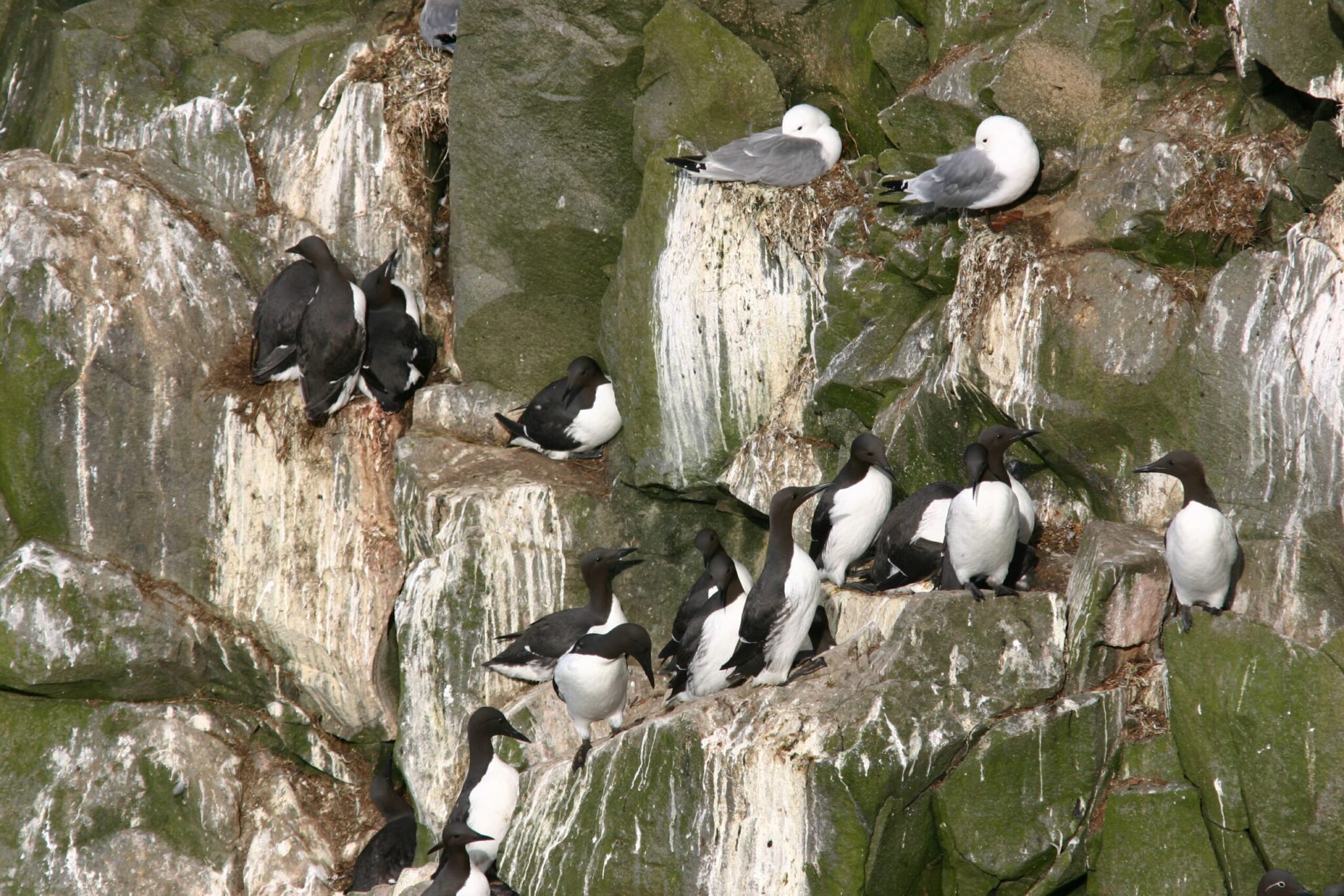
Brünnich's guillemot (Uria lomvia)
Brünnich’s guillemots (Uria lomvia), representing one of four pelagic diving species within the scope of the project, are being instrumented with GLS loggers at 19 SEATRACK localities. Since the North Atlantic population is numerous and widespread IUCN classifies Brünnich’s guillemots as “Least concern”. The breeding population along the coast of mainland Norway is small and classified as “endangered” and despite the robust size of the Svalbard populations they are listed as “Near threatened” due to a constant decline in recent years.
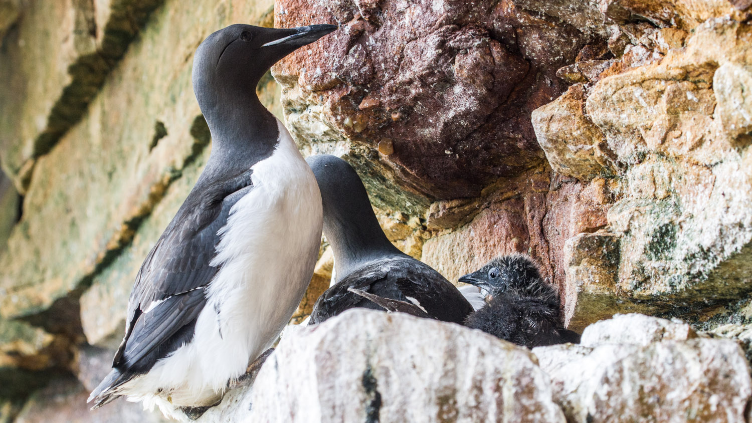
The Brünnich’s guillemot or thick-billed murre are distributed across the polar and sub-polar regions of the Northern Hemisphere. Adult birds are black on the head, neck, back and wings with white underparts. They are darker in color than the common guillemots and have a thicker, shorter bill with white gape stripe.
The Brünnich’s and common guillemots are the largest extant auks (Alcidae) and have the highest flight cost, for their body size, of any animal. Brünnich’s guillemots are accomplished divers, reaching depths of up to 150 m, diving for up to four minutes at a time. They feed primarily on fish such as small gadoids sand-lance and capelin as well as the pelagic amphipods.

Locations
- Alkefjellet – Svalbard, Norway
- Bjørnøya (Bear Island) – Svalbard, Norway
- Cape Graham Moore, Canada [There are no data currently available]
- Coats Island, Canada
- Gorodetskye ptich`i bazary (Cape Gorodetskiy), Russia
- Grímsey (Grimsey), Iceland
- Hornøya (Hornoya), Norway
- Isfjorden – Svalbard, Norway
- Jan Mayen, Norway
- Langanes, Iceland
- Látrabjarg (Latrabjarg), Iceland
- Karskiye Vorota (Kara Gate), Russia
- Kippaku, Greenland
- Koval’skijfjella – Svalbard, Norway [There are no data currently available]
- Kongsfjorden – Svalbard, Norway
- Sermilinnguaq, Greenland
- Oranskie Ostrova(Oranskie Islands), Russia
- Prince Leopold Island, Canada
- Qaanaaq, Greenland [There are no data currently available]
- Zemlya Frantsa-Iosifa (Franz Josef Land), Russia
- All sites
Common eider (Somateria mollissima)
Common eiders (Somateria mollissima), representing one of two coastal diving species within the scope of the project, are being instrumented with GLS loggers at 10 SEATRACK localities. The IUCN categorizes the European common eider population as “Near threatened”, due to moderate declines in recent years. The Norwegian population is classified as “Near threatened” as well due to 15-30 % decline in the last 15 years while the Svalbard population as considered stable.

Common eiders are distributed over the northern coasts of Europe, North America, eastern Siberia and southern Greenland. It breeds in the Arctic and northern temperate regions, but its range expands during winter.
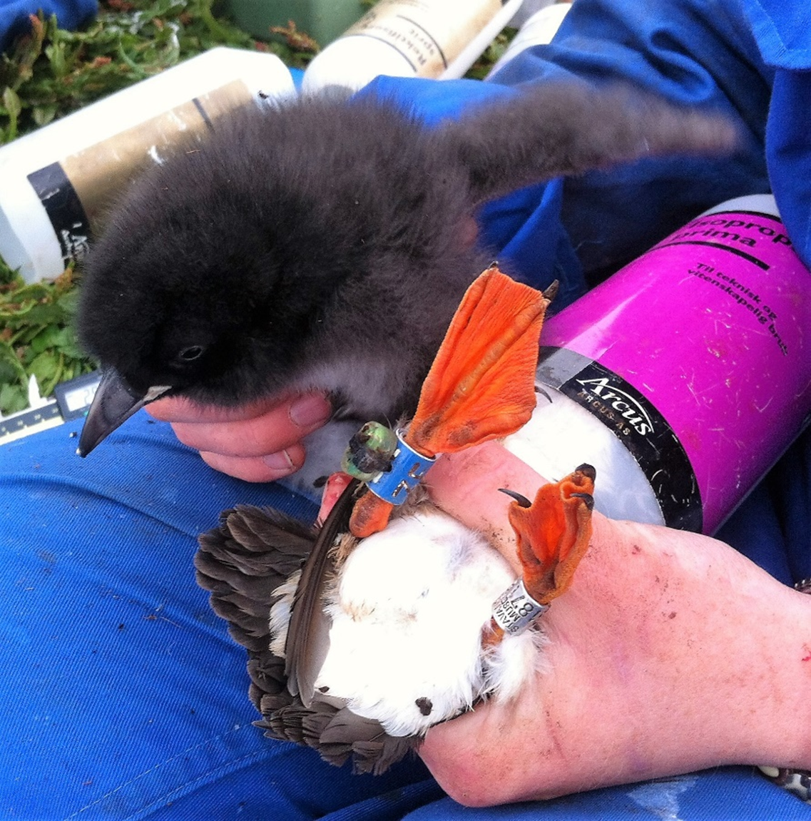
The common eider is the only duck included in SEATRACK and since male eiders do not partake in incubation or chick-rearing only females are instrumented with loggers.
Breeding males have a white head except for a black coronal region, divided by white streak over central crown to nape and pale green patches on nape and rear-ear coverts. Their upperparts are white, breast is rosy-pink, rump, tail and rest of underparts are black. Females are brown with black bars.
Eiders mainly feed on marine and aquatic invertebrates, mostly molluscs and crustaceans.
Locations
- Breiðafjörður (Breidafjordur), Iceland
- Føroyar (Faroe Islands)
- Grindøya (Grindoya), Norway
- Hvaler, Norway [There are no data currently available]
- Kongsfjorden – Svalbard, Norway
- Mandal & Lindesnes, Norway
- Nesodden, Norway [There are no data currently available]
- Selvær (Selvaer), Norway
- Sklinna, Norway
- Solovetskiye Ostrova (Solovetsky archipelago), Russia
- All sites
Common guillemot (Uria aalge)
Common guillemots (Uria aalge), representing one of four pelagic diving species within the scope of the project, are being instrumented with GLS loggers at 16 SEATRACK localities. Since the North Atlantic population is numerous and widespread IUCN classifies Common guillemots as “Least concern”. The breeding populations along the coast of mainland Norway are small and classified as “Critically endangered” and Svalbard populations as “Vulnerable” but only about 100–200 pairs breed in Svalbard outside Bjørnøya where over 240000 pairs breed. In Bjørnøya and Hornøya the populations are recovering after a large-scale population crashes in the eighties but elsewhere populations remain small or gone locally extinct. In 2019, SEATRACK also started deploying GLS loggers on common guillemot chicks at one location (Bjørnøya).
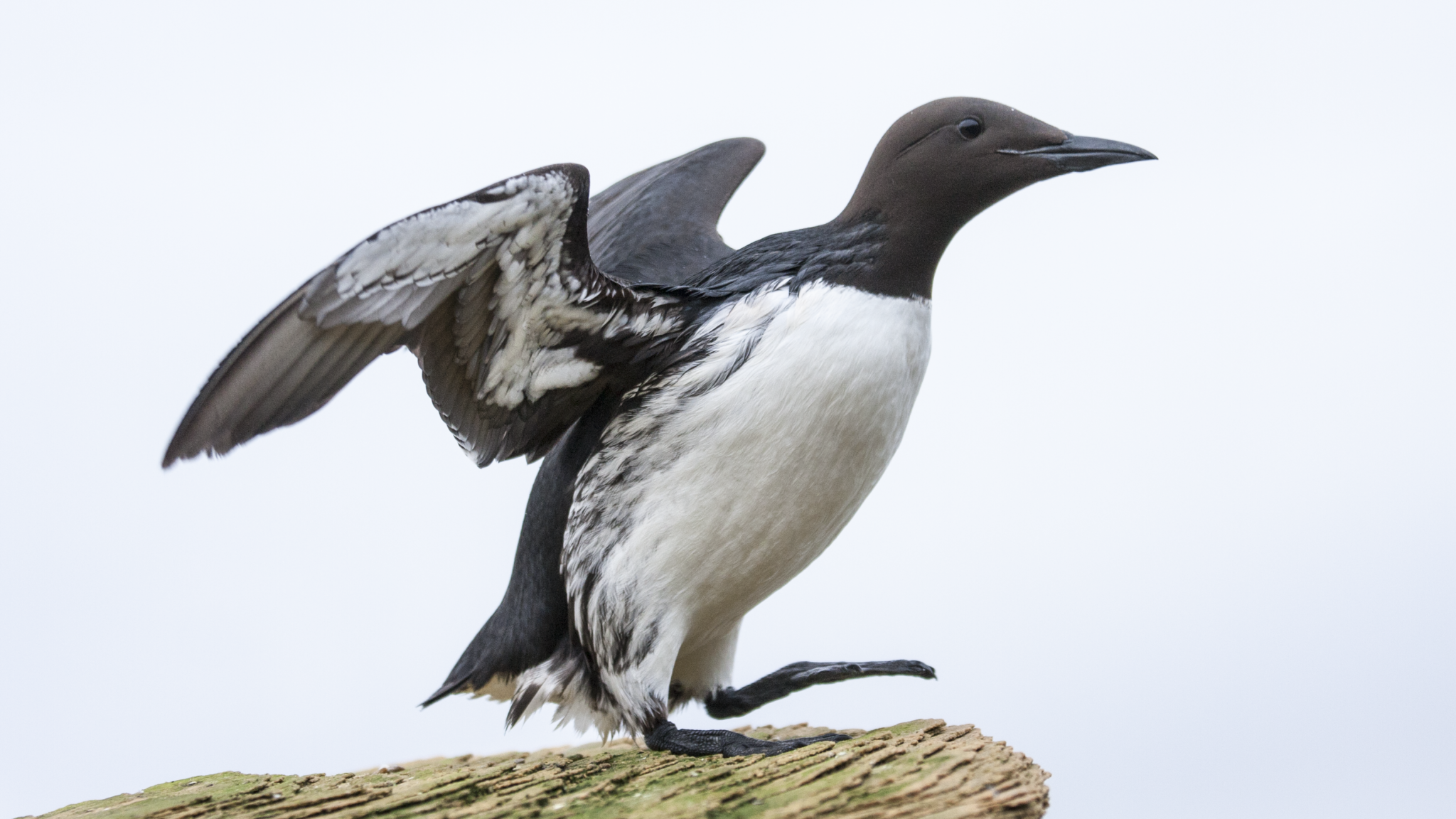
The common guillemot or common murre has a circumpolar distribution, occurring in the low-arctic and boreal waters of the north Atlantic and north Pacific. The common guillemot is distinguishable from the Brünnich’s guillemot by the longer and more pointed bill without the white stripe at the base of the upper mandible, and by the dark mottled marks along the flanks.
The common and the Brünnich’s guillemots are the largest extant auks (Alcidae) and have the highest flight cost, for their body size, of any animal. They are accomplished divers, reaching depths of 170-230 m. Common guillemots feed primarily on schooling pelagic fish such as capelin, sand-lance and small gadoids.
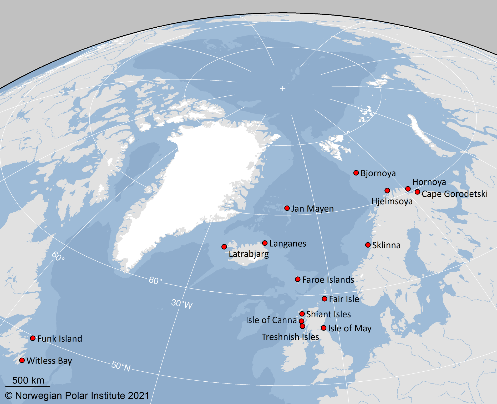
Locations
- Bjørnøya (Bear Island) – Svalbard, Norway
- Fair Isle, United Kingdom [There are no data currently available]
- Funk Island, Canada
- Føroyar (Faroe Islands)
- Gorodetskye ptich`i bazary (Cape Gorodetskiy), Russia
- Hjelmsøya (Hjelmsoya), Norway
- Hornøya (Hornoya), Norway
- Isle of Canna, United Kingdom
- Isle of May, United Kingdom
- Jan Mayen, Norway
- Langanes, Iceland
- Latrabjarg, Iceland
- Shiant Isles, United Kingdom [There are no data currently available]
- Sklinna, Norway
- Treshnish Isles, United Kingdom [There are no data currently available]
- Witless Bay, Canada
- All sites
European shag (Phalacrocorax aristotelis)
European shags (Phalacrocorax aristotelis), representing one of two coastal diving species within the scope of the project, are being instrumented with GLS loggers at 7 SEATRACK localities. Since the North Atlantic population is numerous and widespread the IUCN classifies European shags as “Least concern”. In Norway the species has been relatively stable in the past 30 years and therefore also considered to be of “Least concern” on the Norwegian red list.

The European shag can be found along the entire Atlantic coast of Europe including Iceland and as far south as the coast of Morocco. It ranges in the entire Mediterranean nesting on parts of the coastline of most European and North African countries, as well as parts of the Black Sea coast.
European shags are mainly black in colour with a metallic green-tinged sheen on the feathers and a yellow throat-patch. During the breeding season they have a small crest. European shags feed on a wide range of benthic, demersal and schooling, pelagic fish.

Locations
- Isle of May, United Kingdom
- Jarsteinen, Norway
- Melrakkaey, Iceland
- Hornøya (Hornoya), Norway
- Røst (Rost), Norway
- Sem’ Ostrovov (Seven Islands), Russia [There are no data currently available]
- Sklinna, Norway
- All sites
Glaucous gull (Larus hyperboreus)
Glaucous gulls (Larus hyperboreus), representing one of three pelagic surface feeding species within the scope of the project, are being instrumented with GLS loggers at 5 SEATRACK localities. Despite the world population being stable and classified as being of “Least concern” by the IUCN the Svalbard population is categorized as “Near threatened”. Little is known about the trend in the total Svalbard population, but the populations on Bjørnøya and Hopen have declined since the mid-eighties. In 2019, SEATRACK also started deploying GLS loggers on glaucous gull chicks at two locations (Bjørnøya and Kongsfjorden).

The glaucous gull has a circumpolar, high arctic, breeding distribution. In the north-east Atlantic it occurs in Greenland, Iceland, Jan Mayen, Svalbard, Franz Josef Land and Novaya Zemlya.
The glaucous gull is a large gull, similar in size to the great black-backed gull. Adults have a very pale plumage, pale grey on the upper sides of the wings with white wing tips. The feet are light flesh-coloured.
Glaucous gulls are generalist predators that feeds on a wide variety of fish, molluscs, crustaceans, eggs, chicks and adults of other seabirds, insects, carrion, refuse and offal. Birds breeding in or close to bird colonies are often specialized in preying upon eggs, chicks, and adult birds of certain seabird species.
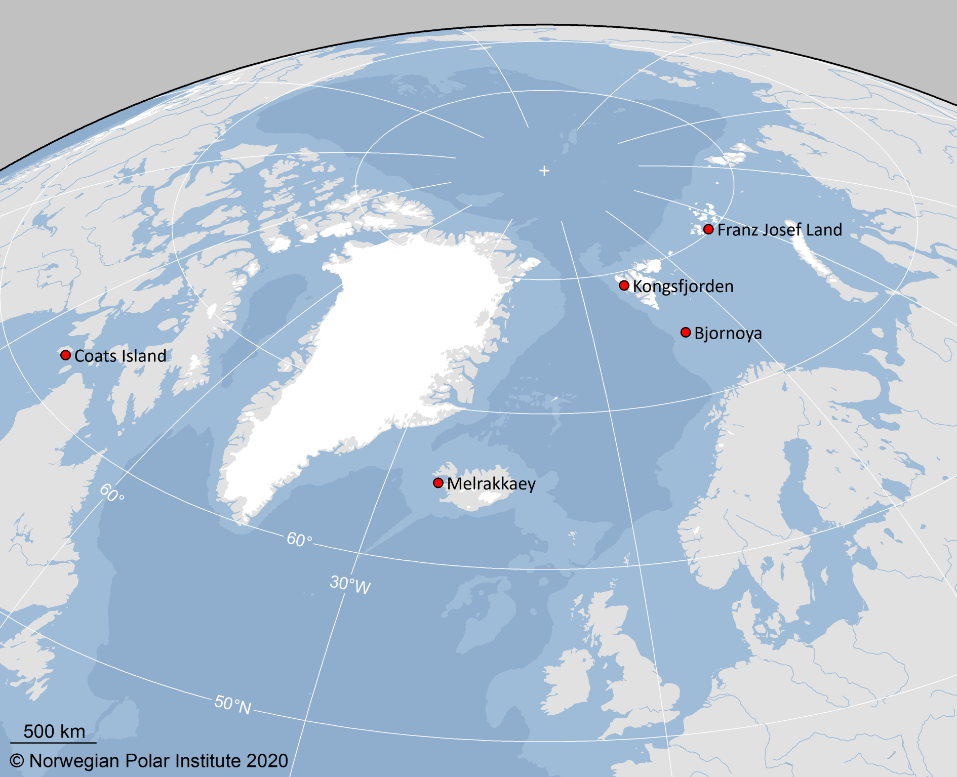
Locations
- Bjørnøya (Bear Island) – Svalbard, Norway
- Coats Island, Canada [There are no data currently available]
- Kongsfjorden – Svalbard, Norway
- Melrakkaey, Iceland
- Zemlya Frantsa-Iosifa (Franz Josef Land), Russia
- All sites
Herring gull (Larus argentatus)
Herring gulls (Larus argentatus), representing one of two coastal surface feeding species within the scope of the project, was initially instrumented with GLS loggers at 11 SEATRACK localities, but new deployment was cancelled in 2017. Herring gulls are widespread and abundant around the North Atlantic and classified as being of “least concern” on IUCN 2015 red list, the same classification applies for the species on the Norwegian red list.

Classification of Herring gull is complicated, but they are members of the Laridae family and are widespread. European herring gulls breed across Northern Europe, Western Europe, Central Europe, Eastern Europe, Scandinavia and the Baltic states. Adults in breeding plumage have a grey back and upper-wings and white head and underparts. The wingtips are black with white mirrors. The bill is yellow with a red spot, eyes are pale with orbital rings ranging from yellow to dull orange. The legs are normally pink. Non-breeding adults have brown streaks on the head and neck.
Herring gulls inhabit coastal and near-coastal areas but can forage inland on large lakes and reservoirs, fields and refuse dumps. The species is highly opportunistic, exploiting almost any available food source e.g. fish, marine and terrestrial invertebrates, carcasses, bird eggs and young, rodents, berries and tubers. They also scavenge at refuse dumps, sewage outfall zones and frequently follow fishing boats.
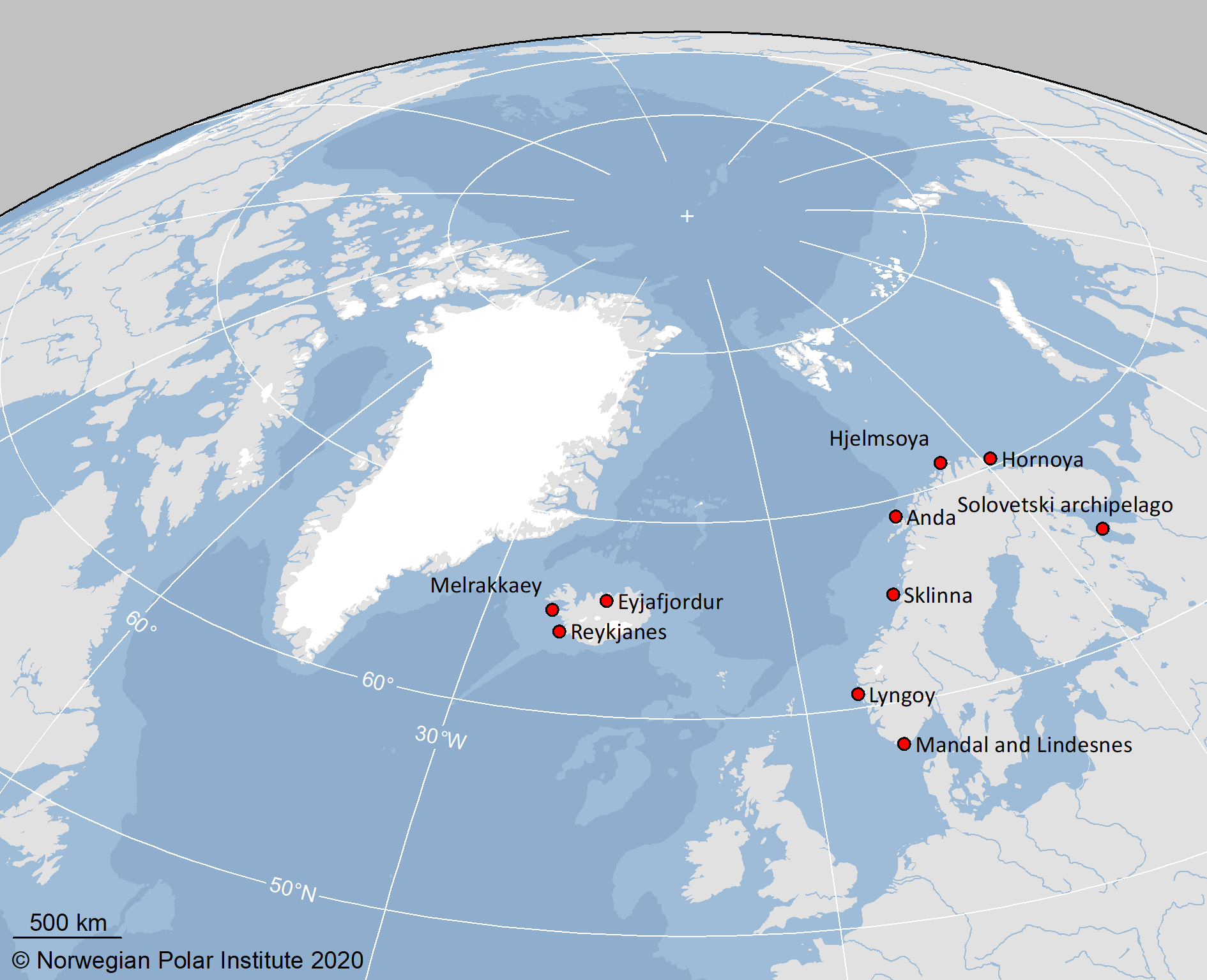
Locations
- Anda, Norway
- Eyjafjörður (Eyjafjordur), Iceland
- Føroyar (Faroe Islands) [There are no data currently available]
- Hjelmsøya (Hjelmsoya), Norway
- Lyngøy, Norway
- Hornøya, Norway
- Mandal & Lindesnes, Norway
- Melrakkaey, Iceland [There are no data currently available]
- Reykjanes, Iceland [There are no data currently available]
- Sklinna, Norway
- Solovetskiye Ostrova (Solovetsky archipelago), Russia
- All sites
Lesser black-backed gull (Larus fuscus)
Lesser black-backed gulls (Larus fuscus), representing one of three pelagic surface feeding species within the scope of the project, was initially instrumented with GLS loggers at 8 SEATRACK localities, but new deployment was cancelled in 2017. The overall trend of lesser black-backed gull populations is increasing and classified as being of “least concern” on IUCN 2015 red list, the same classification applies for the species on the Norwegian red list.

Lesser black-backed gulls are members of the Laridae family and are often classified into three subspecies; L.f. graellsii. L.f. fuscus and L.f. imtermedius. Their breeding range extends from the northern coast of Russia (White-sea), along the coast of Scandinavia, Germany, Belgium, the Netherlands and northern United Kingdom and Iceland. Breeding populations can be found year-round on the coast of Portugal, southern Ireland, the United Kingdom and northern France. Outside the breeding season lesser black-backed gulls disperse widely, spanning the entire North Sea coast, much of the Mediterranean, Black Sea and Caspian Sea coasts, the northern and eastern coasts of Africa, and around the Arabian Peninsula to north-west India. Adults in breeding plumage have a dark grey back and wings, with black wingtips with white mirrors. Head and underparts are white. The bill is yellow with a red spot, eyes are yellow with red orbital rings and legs are normally yellow. Non-breeding adults have brown streaks on the head and neck.
Lesser black-backed gulls are omnivorous, opportunistic feeders but mainly forage at sea. They are mostly piscivourous feeding on small fish such as herring and sand lance but are known to feed on marine and terrestrial invertebrates, bird eggs and young, carrion, offal, rodents and berries. Lesser black-backed gulls often follow fishing vessels, feeding on discarded by-catch.
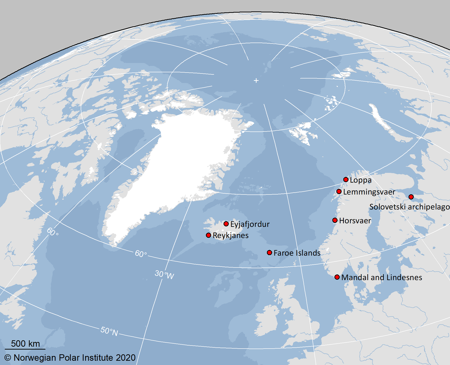
Locations
- Eyjafjörður (Eyjafjordur), Iceland
- Føroyar (Faroe Islands) [There are no data currently available]
- Horsvær (Horsvaer), Norway [There are no data currently available]
- Lemmingsvær (Lemmingsvaer), Norway
- Loppa, Norway [There are no data currently available]
- Mandal & Lindesnes, Norway
- Reykjanes, Iceland
- Solovetskiye Ostrova (Solovetsky archipelago), Russia
- All sites
Little auk (Alle alle)
Little auks (Alle alle), representing one of four pelagic diving species within the scope of the project, are being instrumented with GLS loggers at 7 SEATRACK localities. Little auks are estimated to be one of the most numerous seabird species in the world and classified as being of “least concern” by the IUCN as well as for the Svalbard population on the Norwegian red list. In 2019, SEATRACK also started deploying GLS loggers on little auk chicks at one location (Hornsund).

The little auk or dovkie is a high-arctic species that breeds on eastern Baffin Island (Canada), Greenland, Jan Mayen, Svalbard (including Bjørnøya), Franz Josef Land, Novaya Zemlya and Severnaya Zemlya. They are the smallest of the European auks and have a stocky build, with a short neck and short bill. In summer plumage the head and neck are brown-black except for a white patch above the eye. The upper-parts are black except for a white wing band and the under-parts white.
Little auks feed in both inshore and offshore waters. Their main food during the breeding season consists of small crustaceans. Outside the breeding season, the little auks are pelagic where copepods, especially Calanus spp. are especially important in the diet. Calanus glacialis has been found to dominate the diet in areas with cold arctic water, whereas the smaller and less energy rich C. finmarchicus dominates in areas influenced by warmer Atlantic water.
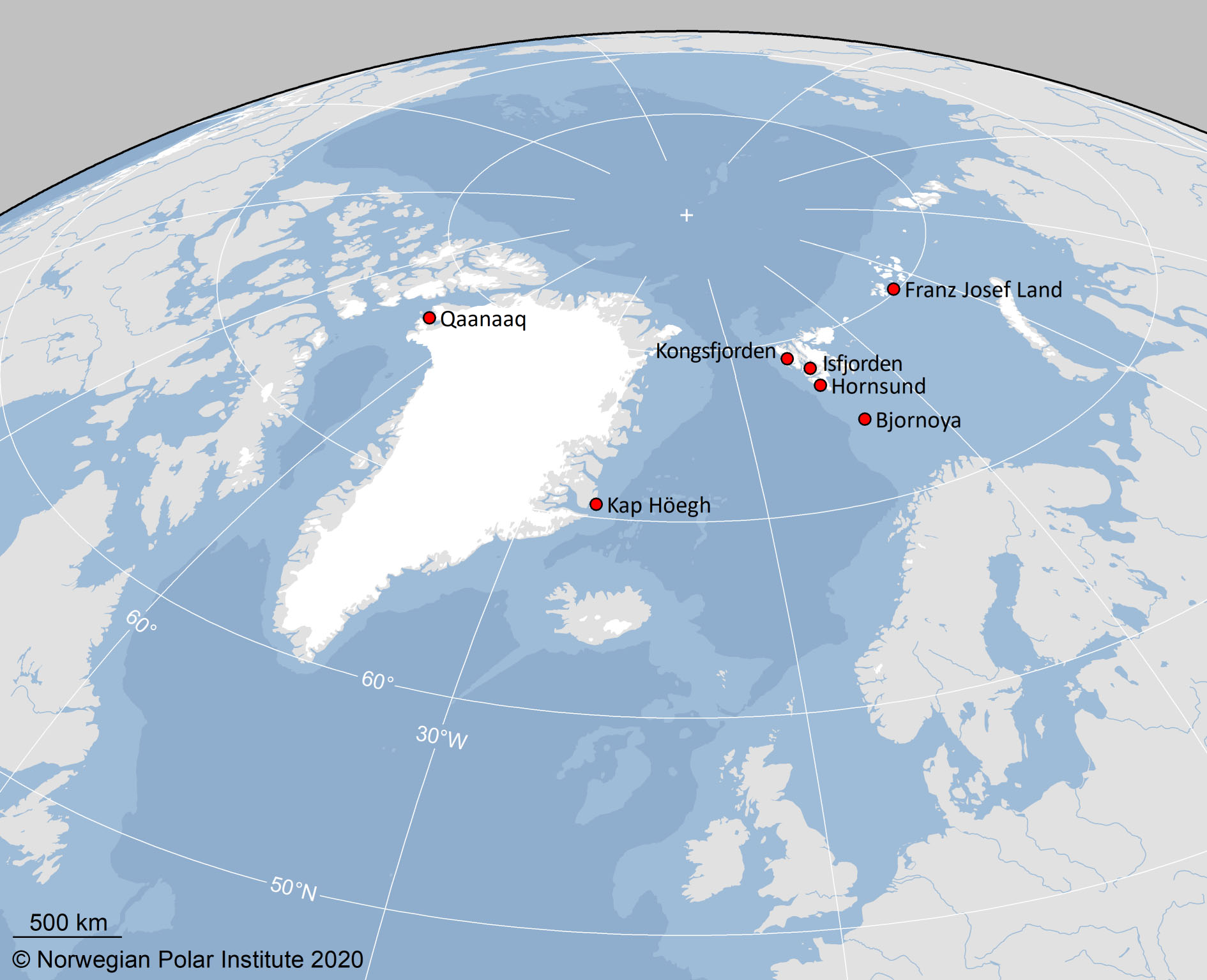
Locations
- Bjørnøya (Bear Island) – Svalbard, Norway
- Hornsund – Svalbard, Norway
- Isfjorden – Svalbard, Norway
- Kap Höegh, Greenland
- Kongsfjorden – Svalbard, Norway
- Qaanaaq, Greenland [There are no data currently available]
- Zemlya Frantsa-Iosifa (Franz Josef Land), Russia
- All sites
Northern fulmar (Fulmarus glacialis)
Northern fulmars (Fulmarus glacialis), representing one of three pelagic surface feeding species within the scope of the project, are being instrumented with GLS loggers at 12 SEATRACK localities. Although fulmars are considered “least concern” by the IUCN and are highly abundant in the North Atlantic with large populations in Svalbard, the population along the coast of the Norwegian mainland has been severely reduced in later years and is therefore classified as “Endangered” on the Norwegian red list. Little is known about the fulmars winter distribution.
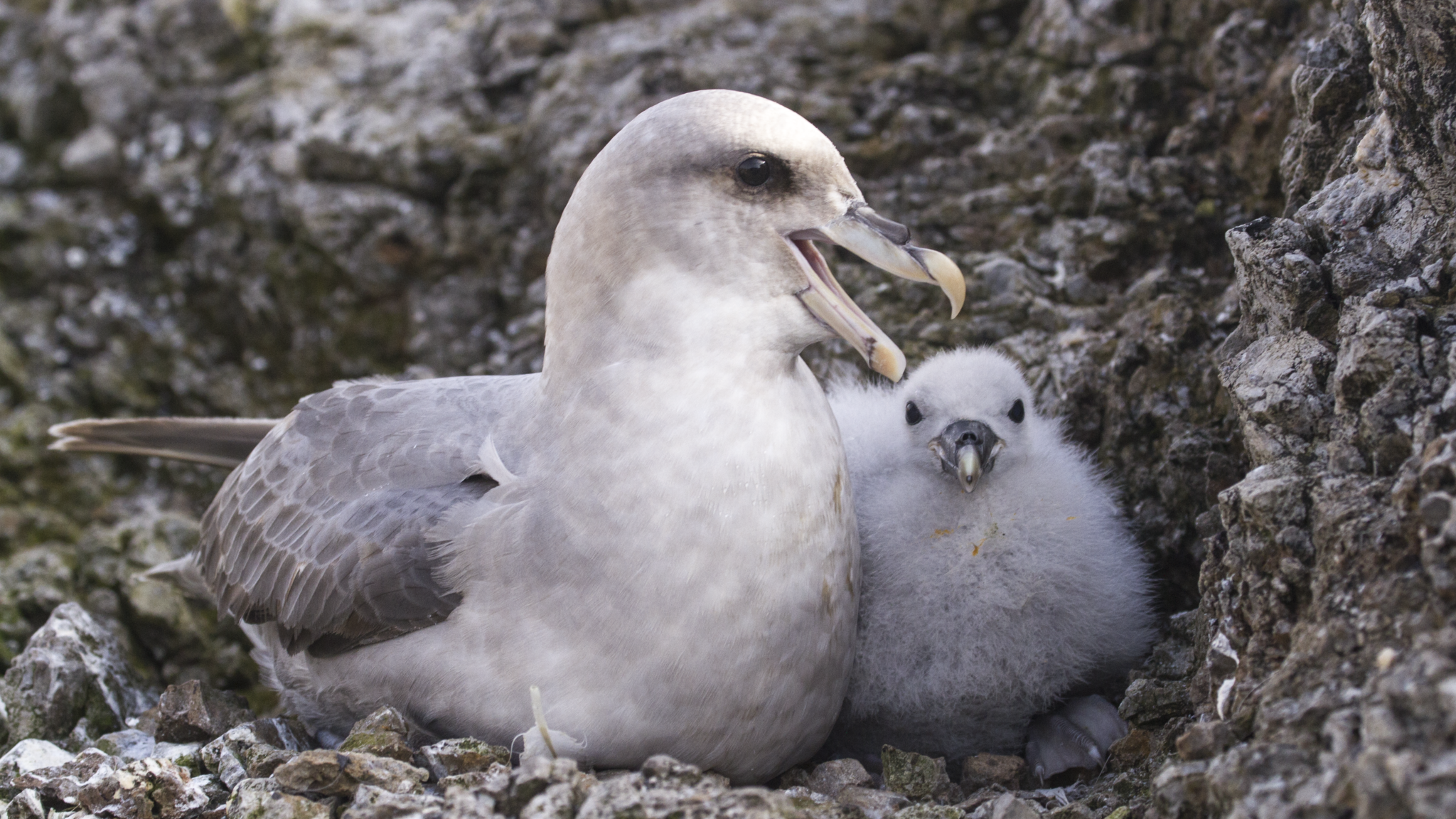
The Northern fulmar, Arctic fulmar or simply fulmar is a highly abundant seabird found primarily in subarctic regions of the North Atlantic and North Pacific oceans. Fulmars exhibit a polymorphism in colour, ranging from a light morph which is almost entirely white, to a dark one which is uniformly gray. Though similar in appearance to gulls, fulmars are in fact members of the Procellariidae family, which include petrels and shearwaters. It and the southern fulmar (Fulmarus glacialodes) together comprise the only extant species in the genus Fulmarus.
Northern fulmars are opportunistic feeders and although their main diet consists of fish, squid, and large zooplankton they also take discarded fish and carrion. They capture prey mainly at the surface but will occasionally dive as well. Northern fulmars tend to forage at marine upwellings and near ice sheets where high densities of large zooplankton can be found but often accompany fishing fleets, forming large aggregations feeding on discarded fish and waste.

Locations
- Alkefjellet – Svalbard, Norway
- Bjørnøya (Bear Island) – Svalbard, Norway
- Eynhallow, United Kingdom
- Føroyar (Faroe Islands)
- Inishmurray, Ireland [There are no data currently available]
- Inishkea Islands, Ireland
- Isle of Canna, United Kingdom
- Jan Mayen, Norway
- Jarsteinen, Norway
- Látrabjarg (Latrabjarg), Iceland [There are no data currently available]
- Little Saltee, Ireland
- Skjálfandi (Skjalfandi), Iceland
- All sites